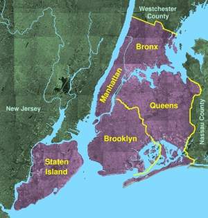
New York City, a global metropolis, is composed of five distinct boroughs: Manhattan, Brooklyn, Queens, The Bronx, and Staten Island. Each borough is geographically unique and contributes to the city’s diverse character, population, and economy.
Manhattan, the smallest borough by land area, is arguably the most iconic. Located at the mouth of the Hudson River, it’s a densely populated island dominated by skyscrapers. Its geography is defined by its urban landscape, featuring Central Park, a vast green space providing respite from the concrete jungle. The island is surrounded by waterways, including the East River and the Harlem River, contributing to its strategic maritime importance. Lower Manhattan, home to Wall Street and the Financial District, occupies the southern tip, while Upper Manhattan showcases cultural landmarks like Columbia University and the Cloisters.
Brooklyn, situated south of Manhattan across the East River, is the most populous borough. Its diverse topography ranges from the flat, sandy beaches of Coney Island to the rolling hills of Prospect Park. Historically an independent city, Brooklyn boasts a rich architectural heritage, particularly in neighborhoods like Brooklyn Heights and Park Slope. Its extensive coastline offers stunning views of the Manhattan skyline. Inland, the borough transitions into vibrant residential areas, each with its own unique identity.
Queens, east of Manhattan and north of Brooklyn, is the largest borough by land area and the most ethnically diverse. Its geography is characterized by vast residential neighborhoods, interspersed with commercial and industrial areas. JFK and LaGuardia airports occupy significant portions of its waterfront. Queens features long stretches of coastline along the East River and the Long Island Sound, offering recreational opportunities and maritime access. The borough’s interior includes expansive parklands, providing green spaces for residents.
The Bronx, the northernmost borough, is the only one primarily on the mainland of the United States. The Harlem River separates it from Manhattan. Its landscape is a mix of residential areas, parklands, and industrial zones. Van Cortlandt Park, one of the city’s largest parks, offers vast green spaces for outdoor activities. The Bronx is also home to the Bronx Zoo and the New York Botanical Garden, adding to its recreational and educational appeal. The geography also includes the industrial waterfront, contributing to its diverse economy.
Staten Island, the southernmost borough, is an island separated from New Jersey by the Arthur Kill and the Kill Van Kull waterways. It’s the least densely populated borough and offers a more suburban environment compared to the others. Its topography includes rolling hills, woodlands, and extensive shorelines. The Staten Island Greenbelt, a large network of parks and natural areas, provides a significant amount of green space. The Verrazano-Narrows Bridge connects Staten Island to Brooklyn, while ferry service provides access to Manhattan.
The interplay between the distinct geographies of each borough contributes to the unique character and complexity of New York City, making it a vibrant and globally significant urban center.