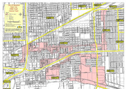
The 5th Ward of Houston, Texas, is a historically significant and culturally rich neighborhood located northeast of downtown. Its boundaries are generally defined by Buffalo Bayou to the south, Liberty Road to the east, Lockwood Drive to the north, and the Union Pacific Railroad tracks to the west.
Understanding the map of the 5th Ward requires acknowledging its grid-like street layout, which is typical of many early Houston neighborhoods. Major thoroughfares like Lyons Avenue and Jensen Drive bisect the area, serving as commercial corridors and arteries for transportation. Smaller residential streets branch off these main roads, revealing a patchwork of single-family homes, shotgun houses (a characteristic architectural style), and increasingly, newer developments.
Key landmarks on the map highlight the 5th Ward’s diverse character. The DeLuxe Theater, a restored Art Deco movie palace, stands as a testament to the community’s cultural heritage and its ongoing revitalization efforts. It serves as a performance venue and a symbol of pride. Further south, along Buffalo Bayou, one finds green spaces and trails that offer recreational opportunities and connect the 5th Ward to the city’s larger park system. Wheatley High School, a historically Black high school, holds immense importance, having educated generations of 5th Ward residents and community leaders.
The map also reveals the presence of various places of worship. Churches are deeply ingrained in the fabric of the 5th Ward, representing diverse denominations and serving as important social hubs. These churches often play a vital role in community outreach, providing support services and fostering a sense of unity.
Looking closely at a map of the 5th Ward also hints at the challenges it has faced. Historically, the neighborhood suffered from underinvestment, infrastructure issues, and environmental concerns due to its proximity to industrial areas. The railroad tracks that define its western border have historically served as a physical and symbolic barrier, separating it from other parts of the city.
However, recent years have seen increased attention and investment aimed at addressing these challenges. Community organizations, local businesses, and government initiatives are working to improve infrastructure, promote affordable housing, and revitalize commercial areas. These efforts are gradually transforming the map of the 5th Ward, bringing new opportunities and enhancing the quality of life for its residents.
The map of the 5th Ward is more than just a depiction of streets and buildings. It’s a visual representation of a community with a rich history, a resilient spirit, and a promising future. It reflects the neighborhood’s past struggles, its present realities, and its ongoing journey toward revitalization and progress.