The Map of Bible Lands is not a single, static image, but rather a dynamic representation encompassing a vast geographical area and a long period of history. It’s an ever-evolving composite picture reflecting the landscapes where the events of the Old and New Testaments unfolded.
The primary geographical focus is the Fertile Crescent, an arc of arable land stretching from Mesopotamia (modern Iraq) through Syria and into the Levant (modern Israel, Palestine, Lebanon, and Jordan). Mesopotamia, the “land between the rivers” (Tigris and Euphrates), was the cradle of civilization, and figures prominently in the Old Testament, with cities like Ur (Abraham’s birthplace) and Babylon serving as significant settings.
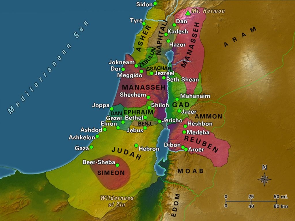
The Levant, also known as Canaan in the Old Testament, is central to the biblical narrative. This relatively small strip of land held strategic importance due to its location as a land bridge connecting Africa, Asia, and Europe. It was the Promised Land for the Israelites, and its diverse terrain includes coastal plains, mountains, and deserts. Key locations here include Jerusalem, Bethlehem, Nazareth, the Sea of Galilee, and the Jordan River, all pivotal in both the Old and New Testaments.
To the west of the Levant lies the Mediterranean Sea, a crucial artery for trade and travel in biblical times. The apostle Paul’s missionary journeys extensively utilized sea routes, connecting cities like Ephesus, Corinth, and Rome. The influence of the Roman Empire, which controlled much of the Bible lands during the New Testament period, is evident in the infrastructure, legal systems, and political structures described in the Gospels and Acts.
Beyond these core areas, the map extends to Egypt, a major power in the Old Testament era, often in conflict with Israel. Mount Sinai, where Moses received the Ten Commandments, is located in the Sinai Peninsula. To the east, we find Persia (modern Iran), which played a significant role in the post-exilic period, as recounted in the books of Ezra and Nehemiah.
Understanding the geography of the Bible lands provides valuable context for interpreting the scriptures. The arid conditions of the desert shaped the nomadic lifestyle of the early patriarchs. The fertile valleys of the Jordan River allowed for agriculture and supported larger populations. The mountainous terrain provided natural defenses and served as places of refuge.
Furthermore, recognizing the strategic importance of the region helps explain the constant warfare and political intrigue described in the Bible. Control of trade routes and access to resources fueled conflicts between kingdoms and empires. The location of Israel as a buffer state between major powers made it a frequent battleground.
Modern maps of the region reflect political boundaries that have changed dramatically over time. While the ancient names may remain, the present-day political realities are different. However, by studying historical maps and accounts, we can gain a deeper appreciation for the land where the stories of the Bible took place, bringing the scriptures to life and enhancing our understanding of the historical and cultural context in which they were written.