
Albemarle County, Virginia, is nestled in the heart of the Piedmont region, a geographical area clearly reflected in its map. Understanding the map of Albemarle County is crucial to navigating its diverse landscape, comprehending its infrastructure, and appreciating its vibrant communities. The most prominent feature on any map of Albemarle County is the Blue Ridge Mountains, which form the county’s western border. These mountains, part of the larger Appalachian range, are responsible for the county’s rolling hills and scenic vistas. The mountain peaks and ridges define the western edge of the county, creating a natural barrier and shaping the flow of watercourses. Eastward from the mountains, the land gradually flattens into fertile farmland and wooded areas. The map reveals a network of rivers and streams that crisscross the county, most notably the Rivanna River, which bisects Albemarle from west to east. The Rivanna provides not only a vital water source but also serves as a recreational corridor. Smaller tributaries like the Mechums River, Moore’s Creek, and Ivy Creek feed into the Rivanna, creating a complex watershed that influences the region’s ecology and development patterns. Roads are a key component of Albemarle’s map. Interstate 64 (I-64) cuts through the southern part of the county, connecting Charlottesville with Richmond to the east and the Shenandoah Valley to the west. U.S. Route 29, a major north-south thoroughfare, runs through the center of the county, connecting it to Northern Virginia and points south. These highways serve as vital transportation arteries for commerce and tourism. Numerous secondary roads and county routes branch off from these main arteries, providing access to more rural areas and residential neighborhoods. The city of Charlottesville, while politically independent from Albemarle County, is geographically embedded within it, creating a unique dynamic. The map shows how Charlottesville acts as a central hub, surrounded by Albemarle’s residential areas, farms, and vineyards. Many residents of Albemarle County commute to Charlottesville for work, education, and entertainment, blurring the lines between the city and the county. The map also illustrates the distribution of population centers within Albemarle County. Besides Charlottesville, key communities include Crozet, located west of Charlottesville near the Blue Ridge Mountains; Scottsville, a historic town situated on the James River; and North Garden, known for its agricultural heritage. These communities are scattered across the county, each with its distinct character and contributing to Albemarle’s overall diversity. Beyond roads and communities, a map of Albemarle County highlights areas designated for conservation and recreation. The Shenandoah National Park borders the county to the west, providing opportunities for hiking, camping, and enjoying the natural beauty of the Blue Ridge Mountains. County parks, such as Darden Towe Park and Walnut Creek Park, offer local residents spaces for outdoor activities and leisure. In conclusion, a map of Albemarle County, Virginia, provides a comprehensive overview of its geography, infrastructure, and communities. From the majestic Blue Ridge Mountains to the fertile valleys and flowing rivers, the map reflects the county’s diverse landscape and its integral relationship with the surrounding environment. Understanding the map is essential to appreciating the unique character of Albemarle County and its place within the broader context of Virginia.
 785×776 albemarle county virginia map rand mcnally charlottesville from www.mygenealogyhound.com
  1974×2600 albemarle county va wall map premium style marketmaps mapsales from www.mapsales.com
  800×800 albemarle county map virginia from www.mapsofworld.com
  1974×2600 albemarle county va wall map color cast style marketmaps mapsalescom from www.mapsales.com
  803×803 albemarle county map virginia usa from www.whereig.com
  1170×1390 map albemarle county virginia stock photo alamy from www.alamy.com
  1588×2249 albemarle county virginia wall map homeowner etsy from www.etsy.com
 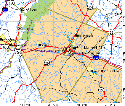 422×359 albemarle county virginia detailed profile houses real estate cost from www.city-data.com
  1378×1536 albemarle county map virginia county maps from uscountymaps.com
  191×250 albemarle county va wall maps mapsales from www.mapsales.com
  900×597 map albemarle county va great lakes map from greatlakesmap.blogspot.com
  1600×2400 map albemarle county va including charlottesville antique map from www.ebay.com
  458×600 albemarle county va map book red from www.deliverymaps.com
  1080×1201 area albemarle magazine from www.albemarlemagazine.com
  1024×1024 albemarle county virginia map white background red banner stock from www.istockphoto.com
  300×300 albemarle county va from www.bestplaces.net
  458×600 albemarle county va wall map color cast style marketmaps mapsales from www.mapsales.com
 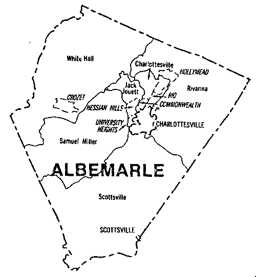 500×542 albemarle county virginia map robbin wood blog from storage.googleapis.com
  250×333 albemarle county va map book red style from www.deliverymaps.com
  500×375 framed map historic albemarle county virginia from www.worthpoint.com
  850×633 satellite map albemarle county from www.maphill.com
  1187×1536 boundaries albemarle county faded contours from www.fadedcontours.com
  301×129 albemarle county satellite map virginia actual from www.city2map.com
  612×408 map albemarle county virginia state white background single from www.istockphoto.com
  800×512 albemarle county launches gis web mapping tool from augustafreepress.com
  415×441 map albemarle county map albemarle county virginia peyton from www.pinterest.com
  800×347 filemap virginia highlighting albemarle countysvg wikimedia commons from commons.wikimedia.org
  850×633 physical map albemarle county from www.maphill.com
  180×135 albemarle county va wall maps mapsalescom from www.mapsales.com
  400×400 albemarle county map locator from www.awesomestories.com
  800×600 albemarle county va geographic facts maps mapsofnet from www.mapsof.net