
Alpine, Arizona, nestled high in the White Mountains, is a haven for outdoor enthusiasts and those seeking a tranquil escape. Understanding its geography via a map is key to appreciating what this charming community has to offer.
A map of Alpine reveals its location in eastern Arizona, near the New Mexico border. It sits within Apache County, surrounded by the Apache-Sitgreaves National Forests. The town itself is relatively small and compact, clustered around US Highway 180 and State Route 261. These highways provide the primary access points, connecting Alpine to larger towns like Springerville and Eagar to the west and Luna, New Mexico, to the east. Due to its high altitude (around 8,000 feet), winter weather can significantly impact travel; therefore, checking road conditions before venturing out, especially during the colder months, is crucial.
Looking at a topographical map, you’ll notice the dramatic elevation changes surrounding Alpine. The terrain is characterized by rolling hills, steep canyons, and dense forests of ponderosa pine, aspen, and spruce. This varied landscape provides a rich habitat for wildlife, including elk, deer, black bear, and various bird species. The map highlights the proximity to numerous hiking trails, campgrounds, and fishing spots, making Alpine a popular base for exploring the wilderness.
Several waterways are visible on the map, contributing to the area’s ecological diversity and recreational opportunities. The San Francisco River meanders through the region, offering opportunities for fishing and wildlife viewing. Numerous smaller creeks and streams crisscross the landscape, providing water sources for both wildlife and human populations. These water bodies are particularly important given the arid climate of Arizona, making Alpine an oasis of green amidst the dry surrounding areas.
The map also shows the dispersed pattern of development around Alpine. Unlike many towns in Arizona, Alpine has maintained a relatively low population density. You’ll see a mix of residential areas, ranches, and scattered businesses, all blending into the natural environment. This contributes to the town’s peaceful and rural atmosphere. The proximity to vast tracts of national forest land ensures that Alpine remains a place where nature takes center stage.
Beyond immediate proximity, a larger map places Alpine within the broader context of the White Mountains region. It reveals the proximity to other popular destinations, such as Big Lake, a renowned fishing spot, and Sunrise Park Resort, a popular ski area. This strategic location makes Alpine an ideal starting point for exploring the diverse attractions of the White Mountains.
In summary, a map of Alpine, Arizona, offers more than just directions. It’s a key to understanding the town’s unique character, its connection to the surrounding wilderness, and the opportunities it provides for outdoor adventure and peaceful retreat. Whether you’re planning a visit or simply curious about this hidden gem in the mountains, consulting a map is an essential first step.
 590×340 alpine arizona alpine from mail.alpinearizona.com
  406×352 alpine arizona white mountains az from www.arizona-leisure.com
  1092×1390 alpine arizona map united states america from www.alamy.com
 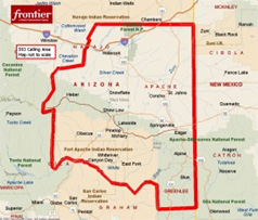 238×203 alpine arizona coverage map from www.alpinearizona.com
  637×1024 alpine acre forested homesites arizona land sale from arizonaland.com
  862×1070 alpine az fstopo legacy map forest service topo avenza maps from store.avenza.com
  990×1332 arizonas top peaks prominence climbing hiking from www.summitpost.org
  200×248 map alpine az high res pastmaps from pastmaps.com
  1043×1280 alpine arizona usgs topo map reprint az quad from shop.old-maps.com
  1024×1024 alpine az fstopo map forest service topo avenza maps from store.avenza.com
  1728×2592 mytopo alpine arizona usgs quad topo map from www.mytopo.com
  300×300 amazoncom usgs topographic quadrangle map alpine arizona folded from www.amazon.com
  1600×1600 vintage alpine arizona map poster alpine az city road wall art print from mapmory.com
  300×300 places alpine arizona from www.bestplaces.net
  300×300 places alpine zip arizona from www.bestplaces.net
  298×367 alpine topographic map scale arizona from www.yellowmaps.com
  625×365 alpine az trails list alltrails from www.alltrails.com
  763×240 hikes trails alpine alltrails from www.alltrails.com
  516×612 arizona map counties premium high res pictures getty from www.gettyimages.co.uk
  625×365 trails alpine arizona alltrails from www.alltrails.com
  1024×536 discovering alpine arizona hidden gem mountains from www.carolroyseteam.com
  500×616 alpine arizona wikipedia la enciclopedia libre from es.wikipedia.org
  1230×1106 physical map arizona from www.freeworldmaps.net
  709×711 map alpine az arizona from townmapsusa.com
  625×365 az trails alpine list alltrails from www.alltrails.com
 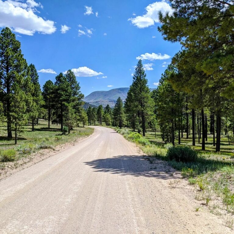 768×768 explore white mountains arizona guidebook map from whythisplace.com