
The map of Europe in 1918 looked drastically different from the map of 1914, and even more so from the map of today. World War I, which concluded in November 1918, redrew borders, birthed new nations, and dismantled old empires, fundamentally altering the political landscape.
The most significant change was the collapse of the great empires. The Austro-Hungarian Empire, once a sprawling multi-ethnic entity, dissolved into several independent states. Austria and Hungary became separate republics, much smaller than their imperial predecessor. From its former territories also arose Czechoslovakia, Yugoslavia (initially the Kingdom of Serbs, Croats, and Slovenes), and significant portions of Poland and Romania. Italy also gained territories from Austria-Hungary, fulfilling irredentist ambitions.
The German Empire, while not entirely dissolved, lost substantial territories. Alsace-Lorraine was returned to France. Significant portions of eastern Germany were ceded to the newly resurrected Poland, creating the Polish Corridor and granting Poland access to the Baltic Sea. This division of Germany created lasting resentment and was a major source of tension in the interwar period. Germany also lost its overseas colonies, which were redistributed among the Allied powers.
The Russian Empire also crumbled. The Bolshevik Revolution of 1917 led to Russia withdrawing from the war and ceding vast territories. Several new nations emerged from the Russian Empire’s western borderlands, including Finland, Estonia, Latvia, and Lithuania. These Baltic states gained their independence and sought to distance themselves from Russia. Poland, as mentioned, was also reborn from parts of the former German, Austrian, and Russian empires.
The Ottoman Empire, weakened by internal strife and defeat in the war, was significantly reduced in size. While Turkey proper survived as an independent nation, the Ottoman territories in the Middle East were placed under mandates of the League of Nations, effectively controlled by Britain and France. This laid the groundwork for future conflicts and the emergence of modern Middle Eastern states.
Romania doubled in size, gaining Transylvania, Bessarabia, and Bukovina. Greece also expanded its territory, although its ambitions in Asia Minor were later thwarted by the Turkish War of Independence. Bulgaria, which had sided with the Central Powers, lost territory.
The Treaty of Versailles and other post-war treaties aimed to create a new Europe based on national self-determination. However, the redrawing of borders was not always clean or just, leaving many ethnic minorities within the borders of newly formed nations. This created ethnic tensions and contributed to instability in the interwar period, ultimately leading to further conflict in the 20th century. The map of 1918 represented not just the end of a war, but the beginning of a new, and often turbulent, era in European history.
 600×350 armistice day historical atlas europe november omniatlas from omniatlas.com
  1560×1096 map europe central map from deritszalkmaar.nl
  900×620 map europe map rose bowl from mapofrosebowl.blogspot.com
  484×252 map europe europe labels accurate maps secretmuseum from www.secretmuseum.net
  4336×4272 american victory map europe shortly ww from www.reddit.com
  1300×987 map europe res stock photography images alamy from www.alamy.com
  2773×1985 europe april treaty brest litovsk rmapporn from www.reddit.com
  900×620 treaty brest litovsk historical atlas europe march from omniatlas.com
  474×363 map europe victory central powers from www.reddit.com
  941×1402 map europe from repairmachineamtrak.z13.web.core.windows.net
  807×561 image map europe png alternative history fandom powered from althistory.wikia.com
  612×478 map europe premium high res pictures getty images from www.gettyimages.co.uk
  640×561 map central eastern europe day great war from www.reddit.com
 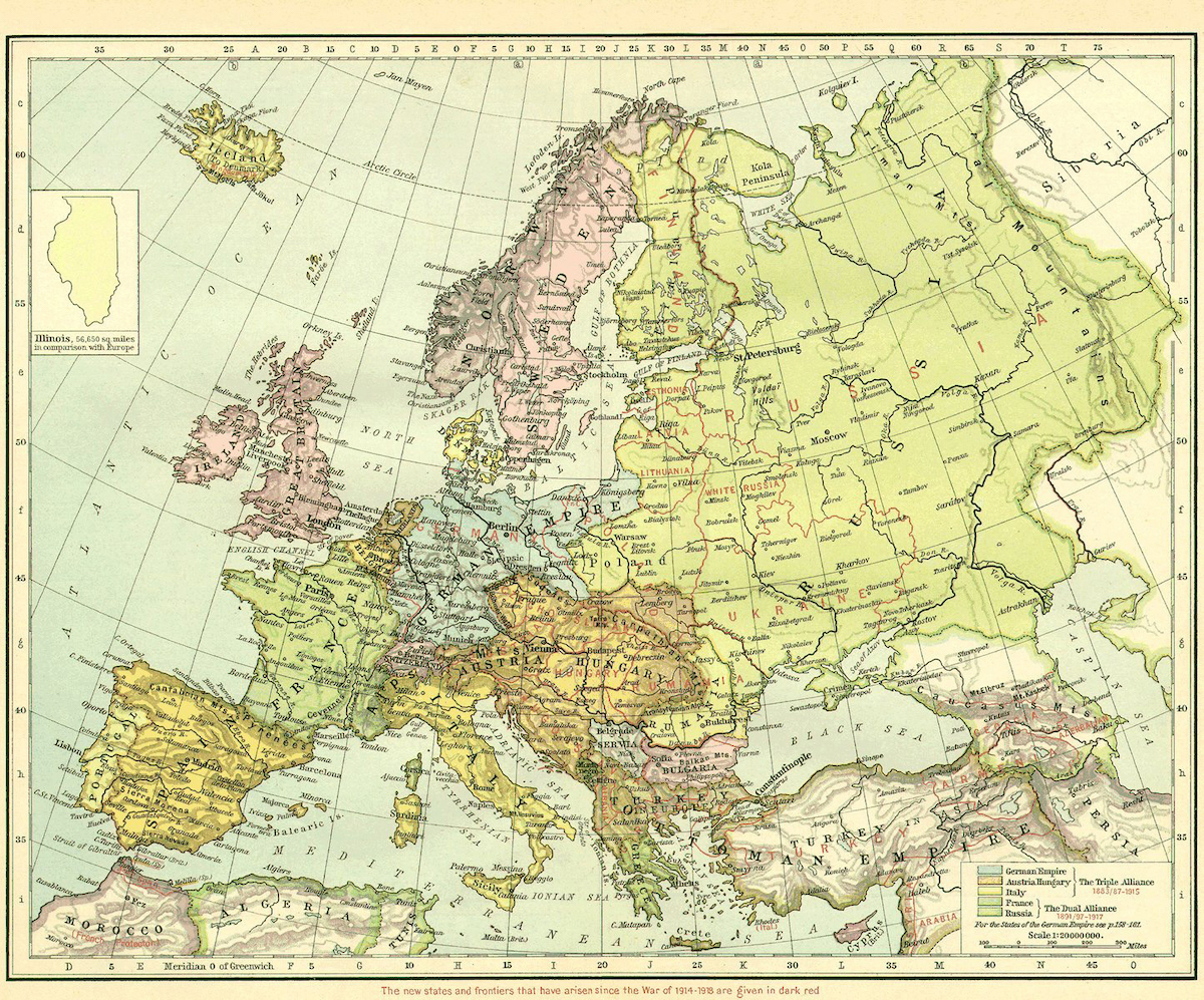 1200×997 map europe world history commons from worldhistorycommons.org
 .png) 1032×828 im alternative history from althistory.wikia.com
1032×828 im alternative history from althistory.wikia.com  900×620 german spring offensive historical atlas europe july from omniatlas.com
  1200×628 ethnographic map europe europe from www.reddit.com
  2400×2062 races europe map mapscomcom from www.maps.com
  1024×576 political map europe from fity.club
  768×768 world war map activity europe maps history gal from byhistorygal.com
  2400×2007 europe wars map shop from www.mapshop.com
  1300×1075 daily telegraph war map europe world war from www.alamy.com
  1080×1080 europe changed from www.rferl.org
  922×721 map europe ralternatehistory from www.reddit.com
  1497×898 europe world war rmapporn from www.reddit.com
  1600×1113 map europe carte ethnographique de leurope antique vintage from www.pinterest.com
  474×301 oldham historical research group world war from www.pixnet.co.uk