
The notorious Five Points neighborhood of 19th-century New York City wasn’t marked on any official municipal map. It existed as a space of overlapping realities, a convergence of marginalized communities, criminal activity, and fleeting glimpses of upward mobility. Therefore, creating a literal “map” of Five Points is less about precise cartography and more about understanding the social, economic, and cultural forces that shaped it.
Imagine a five-pointed star superimposed over lower Manhattan. These points represent the intersections of five streets: Worth Street (formerly Anthony Street), Park Street (formerly Cross Street), Baxter Street (formerly Orange Street), and Little Water Street. The area bordered approximately by Canal Street to the north, Broadway to the west, Pearl Street to the south, and the Bowery to the east, contained this chaotic core. This “map” reveals several key features:
Geographic Challenges and the Collect Pond:
Prior to development, the area was dominated by the Collect Pond, a freshwater source that became heavily polluted and was eventually drained and filled. This landfill created unstable ground, contributing to the area’s dilapidated housing and sanitation problems. The unstable geography directly influenced the built environment. Cheaply constructed tenements replaced the former elegant estates, attracting impoverished immigrants and freed African Americans. Disease thrived in the unsanitary conditions, further solidifying Five Points’ reputation as a dangerous and unhealthy place.
Paradise Square and the Old Brewery:
At the heart of Five Points lay Paradise Square, a small, unpaved open space that served as a hub for social gatherings, public spectacles (often violent), and commerce, both legal and illegal. Nearby stood the Old Brewery, a former brewery transformed into a massive tenement housing hundreds of people. It became synonymous with poverty, crime, and disease, and served as a grim symbol of the neighborhood’s degradation. Missionary efforts targeted the Old Brewery, highlighting the perceived need for moral reform within Five Points.
A Melting Pot of Cultures and Conflict:
The Five Points neighborhood became a melting pot of cultures, primarily Irish immigrants and free African Americans. This intersection of cultures resulted in the blending of musical styles (the roots of tap dance can be traced back to Five Points), foodways, and social customs. However, it also fueled racial tensions and competition for scarce resources. Gangs often formed along ethnic lines, contributing to the pervasive violence. The intersection of these different communities created a vibrant but often volatile social landscape.
The Rise of Criminal Organizations:
Five Points was notorious for its organized crime, with gangs like the Dead Rabbits and the Bowery Boys vying for control of the streets. Petty theft, prostitution, and gambling were rampant. The police struggled to maintain order in the densely populated and often lawless environment. The reputation of Five Points as a haven for criminals became deeply ingrained in the public consciousness.
The Gradual Decline and Erasure:
Over time, efforts were made to “clean up” Five Points. By the late 19th century, reformers pushed for the demolition of slums and the construction of more orderly streets and buildings. The area was gradually redeveloped, and much of the original Five Points was erased from the map. Columbus Park now occupies a significant portion of the former neighborhood. However, the legacy of Five Points continues to fascinate and inform our understanding of urban poverty, immigration, and the complexities of American history.
 602×910 map points manhattan from kr.pinterest.com
  1300×1162 points york res stock photography images alamy from www.alamy.com
  807×1024 map points neighborhood york city flickr from www.flickr.com
  538×640 map points neighborhood york city from www.pinterest.com
  640×909 vintage map points manhattan from www.pinterest.com
  1600×1225 original points nyc donald blanton blog from storage.googleapis.com
  800×947 points nyc map map from deritszalkmaar.nl
  1024×706 renaissance denvers points denver business journal from www.bizjournals.com
 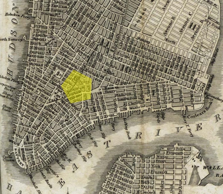 751×652 points nyc map uf summer from carmelleztova.pages.dev
  474×503 points planning development city columbia from planninganddevelopment.columbiasc.gov
  338×324 urbanography gangs lived yorks points district from urbanography.com
  720×455 anthropology practice points landmarks fp from www.anthropologyinpractice.com
  1000×750 wikipedians map points circa showing area from www.pinterest.de
  736×1023 point maps york neighborhoods points map from www.pinterest.com
  670×886 miguel monkc points south map hemispheres magazine united from www.agoodson.com
  396×252 points manhattan facts kids from kids.kiddle.co
  1978×2560 points from www.singletracks.com
  1300×1373 points map res stock photography images alamy from www.alamy.com
 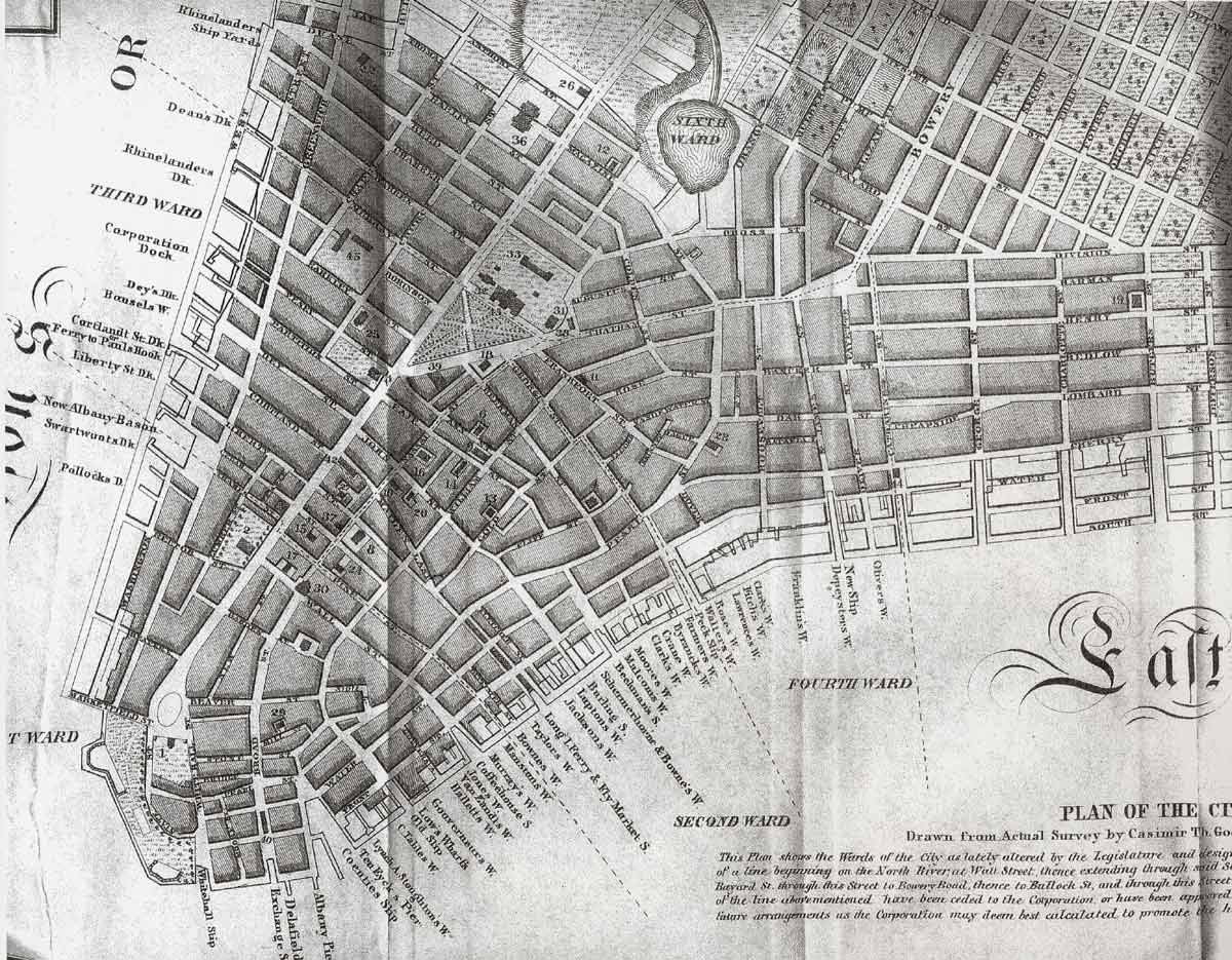 1200×935 points york map from www.lahistoriaconmapas.com
  250×170 york city chinatown links resources from www.nychinatown.org
  1854×2560 festival map directions st pats points columbia sc from stpatscolumbia.com
  1023×662 points york map map from deritszalkmaar.nl
  474×366 points curtis park neighborhood historic nexus from www.pinterest.com
  641×641 aerial photography map points al alabama from www.landsat.com
  549×411 points denver nbhd colorado area map from www.thedirectory.org
  392×334 points south birmingham nbhd alabama regional map from thedirectory.org
  1118×1116 change occur benefit gentrification points from cudenverhistoryjournal.org
 _-_Geographicus_-_CollectPond-hutchings-1846_(cropped).jpg/440px-1846_Broadside_of_the_Collect_Pond%2C_New_York_and_Steam_Boat_(_Five_Points_)_-_Geographicus_-_CollectPond-hutchings-1846_(cropped).jpg) 440×619 points manhattan wikipedia from en.wikipedia.org
440×619 points manhattan wikipedia from en.wikipedia.org  641×641 aerial photography map points fl florida from www.landsat.com
  228×228 points renaissance creations from renaissancecreations.org
  345×412 lived points gsa from www.gsa.gov