
A map of a lake is more than just a pretty picture; it’s a crucial tool for navigation, recreation, and scientific study. It represents a complex body of water in a simplified, understandable format, conveying vital information that helps users safely and effectively interact with the lake environment.
At its core, a lake map depicts the shoreline, the fundamental boundary between land and water. This outline provides an immediate sense of the lake’s shape, size, and overall layout. Detailed maps will show nuances in the shoreline, including peninsulas, bays, islands, and inlets, offering clues about potential fishing spots, sheltered coves, and scenic viewpoints.
Depth contours, often represented by lines called isobaths, are a critical element. These lines connect points of equal depth, allowing users to visualize the underwater topography. Closely spaced contours indicate steep drop-offs, while widely spaced contours suggest gradual slopes. Anglers use these to identify ledges and submerged structures where fish congregate. Boaters rely on them to avoid running aground, especially in shallow areas or near underwater hazards.
Navigational aids are frequently included. These can take the form of buoys marking channels or hazards, or even charted locations of submerged wrecks. These features are essential for safe boating and are often coded according to established maritime standards, making them universally understandable.
The map might also incorporate information about the surrounding land. Roads leading to boat launches, parking areas, campgrounds, and hiking trails are often displayed. The presence of surrounding forests, wetlands, or developed areas can provide context for the lake’s environment and potential recreational opportunities.
Modern lake maps often utilize GPS technology and sonar mapping to provide highly accurate bathymetric data. This data is used to create detailed 3D models of the lakebed, allowing for a much more comprehensive understanding of the underwater landscape. These high-resolution maps are invaluable for scientific research, such as studying sediment distribution, identifying fish habitats, and monitoring water quality.
Beyond navigation and recreation, lake maps play a significant role in lake management. They are used to track changes in water levels, monitor shoreline erosion, and assess the impact of human activities on the lake ecosystem. Conservation efforts, such as wetland restoration or invasive species control, often rely on accurate lake maps to plan and monitor their effectiveness.
Ultimately, a map of a lake is a multifaceted representation that serves a diverse range of purposes. From providing a safe passage for boaters to aiding in scientific research and conservation efforts, it’s a vital tool for anyone who interacts with and cares about the health and well-being of this valuable resource.
 768×623 lake maps show topography favorite canadian lake from the-gadgeteer.com
  1200×818 major lakes world important facts map from mapsforupsc.com
  1920×1440 lake maps galleries from www.sandhurstlake.co.uk
  912×884 topographic lake maps essential tool find from www.pinterest.ph
  2028×1271 contour lake maps florida lakes bathymetric maps boat ramp from printablemapforyou.com
  2200×1700 basin maps international joint commission from ijc.org
  2560×1707 unveiling secrets lakes map comprehensive guide from mapofregina.pages.dev
  1700×2200 lake marion maps charts from fity.club
  650×860 lake maps reveal treasure information american sport fish from americansportfish.com
  480×622 hand drawn maps lake map illustrated map map from www.pinterest.com
  800×800 layers lake maps topography art lake art lake map from www.pinterest.com
  1523×831 brinks fishing lake map from tbrinks.blogspot.com
  1600×1313 lake michigan depth freshwater size map britannica from www.britannica.com
 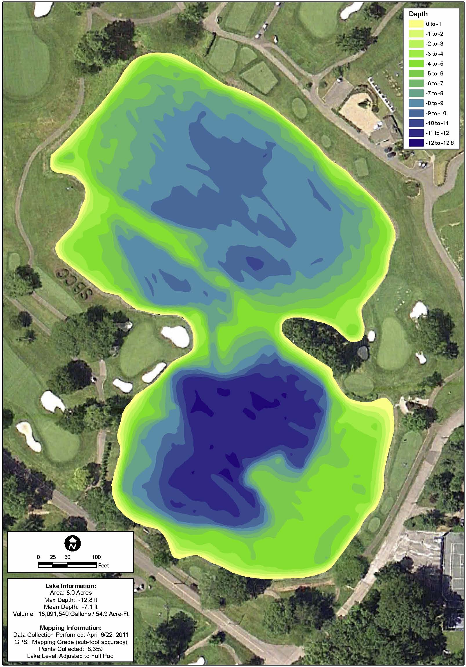 1607×2298 lake map mapping network from mappingnetwork.com
  1000×800 printable great lakes map from lessonmagiccriswell.z19.web.core.windows.net
 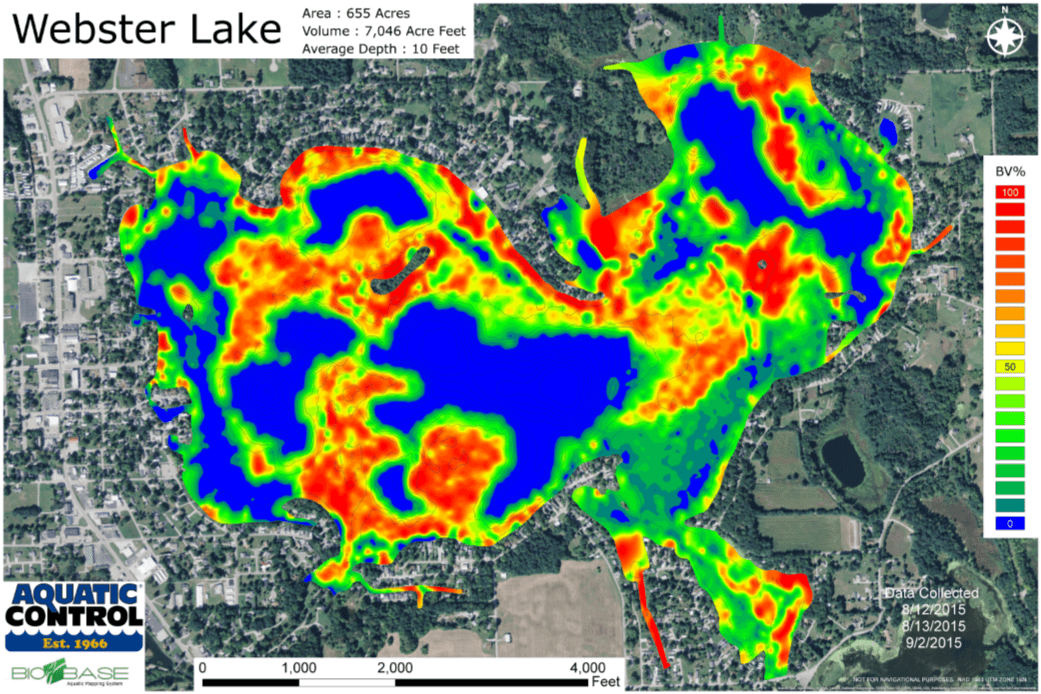 1041×694 lake mapping aquatic control from www.aquaticcontrol.com
  1200×650 map shows location lakes from www.pinterest.com
  780×500 great lakes map wilow kaitlynn from merraleeocarlyn.pages.dev
  3002×2345 map great lakes depicted lake depth rmapporn from www.reddit.com
  1390×2048 great lakes profile vivid maps from vividmaps.com
  1903×1916 bathymetry lake michigan from www.ngdc.noaa.gov
 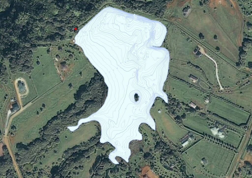 1024×727 lake mapping mapping network from mappingnetwork.com
  1982×3079 nautical maps lake champlain from www.old-maps.com
  1056×816 navigating great lakes comprehensive guide printable maps from mapofregina.pages.dev
 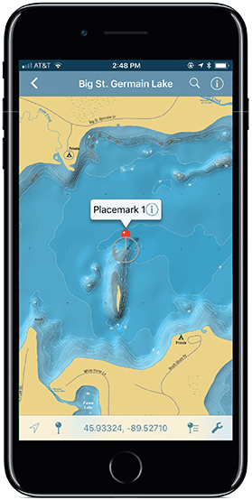 279×554 geospatial lake map images mapping specialists limited from www.mappingspecialists.com
  1024×768 great lakes watershed map river maps from usrivermaps.com
  2000×1274 maps great lakes vivid maps from vividmaps.com
  816×1056 lake overview james pond somerville lincoln maine lakes maine from www.lakesofmaine.org
  800×440 solitude completes lake mapping mapping network from www.solitudelakemanagement.com
  1752×1524 interactive map great lakes from databayou.com
  1178×901 lake mapping mapping network from mappingnetwork.com
 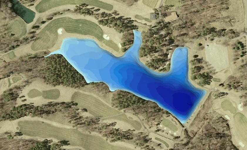 841×513 lakemap mapping network from mappingnetwork.com
  2170×2516 battle lake depth chart visual reference charts chart master from bceweb.org
  1024×859 gps lake map guides lake management plan mapping network from mappingnetwork.com