
Abaco Island, a jewel in the Bahamian archipelago, is best understood with a map. Understanding its geography is key to appreciating its diverse offerings, from tranquil beaches to bustling settlements.
Key Geographic Features: Maps of Abaco highlight its elongated shape, stretching roughly 130 miles long and rarely exceeding 4 miles wide. This ribbon-like configuration contributes to its expansive coastline, dotted with numerous cays and harbors. The Sea of Abaco, a protected body of water nestled between the main island and its barrier islands, is a defining feature, providing calm waters ideal for boating and watersports. Great Abaco, the main island, dominates the landmass.
Settlements and Infrastructure: The main settlements, typically marked prominently on maps, are Marsh Harbour, Hope Town, and Treasure Cay. Marsh Harbour, located roughly in the center of Great Abaco, is the commercial hub, boasting the island’s largest airport, government services, and a bustling harbor. Hope Town, on Elbow Cay, is renowned for its iconic candy-striped lighthouse, a recognizable symbol often featured on tourism maps. Treasure Cay, on the northern part of Great Abaco, is a planned resort community known for its stunning beaches and golf course. Other notable settlements include Green Turtle Cay, Man-O-War Cay (famous for its boatbuilding heritage), and Guana Cay, each possessing its unique charm and appearing on detailed maps.
Roads and Accessibility: The main highway, typically a thin line tracing the length of Great Abaco, connects the major settlements. However, be aware that while a road extends the length of Great Abaco, access to outer cays relies primarily on ferries and boats. Maps will illustrate the ferry routes connecting the main island to the surrounding cays, showcasing the importance of maritime transportation. Roads on outer cays are often limited, with golf carts being a preferred mode of transport.
Natural Attractions: Beyond settlements, maps unveil the natural treasures of Abaco. Abaco National Park, a protected area in the southern part of Great Abaco, is usually marked, indicating an area of diverse ecosystems, including pine forests, wetlands, and mangrove swamps. This park is vital for the endangered Abaco Parrot. The vast network of reefs surrounding Abaco is a major draw for divers and snorkelers, and their locations are often indicated on navigational charts and tourist maps. Sandy beaches, ranging from long stretches of pristine white sand to secluded coves, are depicted along the coastline.
Types of Maps: Various types of maps serve different purposes. Tourist maps often highlight attractions, accommodations, and points of interest, catering to visitors. Navigational charts, essential for boaters, provide detailed information on water depths, navigational aids, and potential hazards. Topographical maps reveal the island’s elevation changes and land features, invaluable for hikers and nature enthusiasts. Understanding which type of map is being used is crucial for accurate interpretation and navigation. Ultimately, a good map of Abaco is your key to unlocking the island’s beauty and navigating its diverse offerings.
 792×1004 abaco estate services map abaco bahamas from abacoestateservices.com
  2237×2978 large abaco maps print high resolution from www.orangesmile.com
  924×1170 abacos tourist map ontheworldmapcom from ontheworldmap.com
 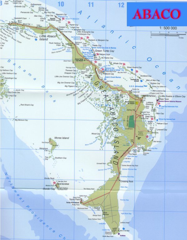 600×767 map abacos bahamas great abaco abaco marsh harbour from www.the-bahama-islands.com
  642×1024 great abaco island bahamas adventure guide map franko maps from store.frankomaps.com
  1300×1390 map great abaco island bahamas geography outlines from www.alamy.com
  735×1102 abacos bahamas island treasure cay bahamas bahamas map from www.pinterest.com.au
  595×758 abaco info maps casuarina point abaco from www.abacopalms.com
  864×1234 island great abaco map from www.billjohnsonartbahamas.com
  1170×1357 map abaco islands from www.notesfromtheroad.com
  550×798 history abaco bahamas island map publishing from www.islandmapstore.com
  978×1500 abacos islands from fity.club
  2993×2394 abacos map wall art print poster abaco islands bahamas caribbean from www.mapsasart.com
  800×800 engraved map abaco island from woodyoubahamas.com
  570×855 abaco islands bahamas space satellite poster map from www.etsy.com
  715×926 abaco map copy grand bahama abaco bahamas green turtle from www.pinterest.com
  496×554 pin abacos islands bahamas from www.pinterest.ca
  1500×1845 abaco bahamas travel guide island hop abacos cays from www.bahamasairtours.com
  350×488 abaco islands bahamas map abaco islands bahamas abaco islands from www.euroradialyouth2016.com
  800×1049 abaco bahamas tourist map abaco bahamas mappery abaco bahamas from www.pinterest.com
  409×284 abacos map bahamas detailed maps abaco islands from ontheworldmap.com
  420×395 abaco bahamas map bahamas vacation travel guide from www.bahamas-travel.info
  2560×2560 visit abaco bahamas abaco sun from abacosun.com
  1920×1358 abacos bahamas caribbeanislandscom from www.caribbeanislands.com
  1276×1649 abaco map explore islands history abaco bahamas from www.pinterest.com
  2758×3584 storm christmas bird count abaco bahamas from www.birdscaribbean.org
  700×855 abaco today from www.abacotoday.com
  474×334 bahamas map abaco island from www.lahistoriaconmapas.com
  1920×1396 large detailed map abacos ontheworldmap vrogueco from www.vrogue.co
 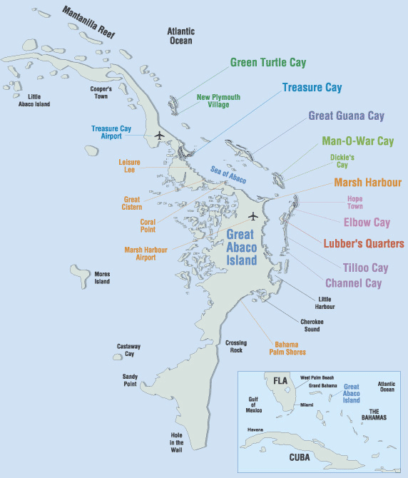 572×670 abaco treasure bahamas islands madurodive blog from blog.madurodive.com
  750×720 abacos boating captial bahamas from www.bahamas.com
  497×497 map hole wall cave great abaco island bahamas from www.researchgate.net