
Aberdeen, Maryland, a city nestled in Harford County, boasts a rich history and a strategic location along the I-95 corridor. Understanding the city’s map is crucial for both residents and visitors seeking to navigate its diverse offerings. The layout reveals a blend of residential neighborhoods, commercial hubs, industrial zones, and recreational spaces, all contributing to Aberdeen’s unique character.
At the heart of Aberdeen lies its downtown area, centered around Main Street. This is the historical and commercial core, featuring a mix of local businesses, restaurants, and government buildings. The map shows Main Street running generally east-west, serving as a primary artery for local traffic. Side streets branching off Main Street lead to residential neighborhoods characterized by a variety of housing styles, from historic homes to more modern developments.
The presence of Aberdeen Proving Ground (APG), a major U.S. Army installation, significantly influences the city’s geography. APG occupies a substantial portion of the land south and east of the city, impacting development patterns and contributing to the local economy. Roads like Route 40 (Pulaski Highway) provide access to APG and also serve as major commercial thoroughfares, lined with retail outlets, hotels, and service industries. These thoroughfares act as important connectors between Aberdeen and neighboring towns.
North of the downtown area, the map reveals a more suburban landscape. Residential developments become more prominent, interspersed with parks and recreational areas. Cal Ripken Sr. Foundation’s Youth Development Park is a well-known landmark shown on maps, drawing visitors for baseball tournaments and other events. The Church Creek area, located in the northeast section of the city, is known for its more established neighborhoods and proximity to natural areas.
The I-95 corridor, running north-south along Aberdeen’s western edge, is a defining feature of the city’s map. This interstate highway provides crucial access to major cities like Baltimore and Philadelphia, making Aberdeen an attractive location for businesses and commuters. Several exits along I-95 serve Aberdeen, directing traffic to various parts of the city. The map also reveals the presence of industrial areas and distribution centers located near the interstate, capitalizing on the ease of transportation.
Aberdeen also boasts a network of smaller roads that connect its various neighborhoods and commercial districts. These roads, often less congested than the main thoroughfares, provide alternative routes for navigating the city. Examining the map reveals the connectivity provided by these local roads, allowing residents to easily access amenities and services throughout Aberdeen.
In conclusion, the map of Aberdeen, Maryland, reflects its diverse character and strategic location. From the historic downtown to the influence of Aberdeen Proving Ground and the vital I-95 corridor, the city’s layout is a testament to its evolving role as a key player in the region. Understanding the map is essential for navigating the city’s various offerings and appreciating its unique blend of history, commerce, and community.
 612×612 aberdeen maryland street map from www.landsat.com
  300×300 aberdeen md from www.bestplaces.net
 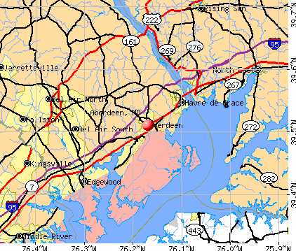 422×359 aberdeen maryland md profile population maps real from www.city-data.com
  1009×768 aberdeen md railfan guide from www.railfanguides.us
  338×338 aberdeen maryland area map from www.thedirectory.org
  3000×2250 antique aberdeen maryland geological survey etsy from www.etsy.com
  684×521 aberdeen md maps robert locklear blog from storage.googleapis.com
  800×480 aberdeen located maryland usa from www.mapsofworld.com
  612×612 aberdeen proving ground maryland street map from www.landsat.com
  648×345 moving aberdeen maryland btobers from www.btobers.com
  1022×1390 aberdeen maryland map united states america from www.alamy.com
  300×300 places aberdeen proving ground maryland from www.bestplaces.net
  600×371 aberdeen tide station location guide from www.tide-forecast.com
  1535×2028 aberdeen topographic map scale maryland from www.yellowmaps.com
  420×350 aberdeen profile aberdeen md population crime map from www.idcide.com
  390×280 imagenes de aberdeen maryland imagenes fotos vectores de stock from www.shutterstock.com
  1024×766 map aberdeen city maryland thong thai real from diaocthongthai.com
  500×637 mytopo aberdeen maryland usgs quad topo map from www.mytopo.com
  400×302 location aberdeen md from www.aberdeenmd.gov
  750×600 aberdeen maryland alchetron social encyclopedia from alchetron.com
  300×300 places aberdeen zip maryland from www.bestplaces.net
  1500×1813 aberdeen maryland topo map mytopo map store from mapstore.mytopo.com
  2000×1172 map maryland cities roads gis geography from gisgeography.com
  1300×956 aberdeen surrounding areas shown road map geography map from www.alamy.com