
Aichi Prefecture, situated in the Chubu region of Japan on the Pacific coast, boasts a diverse landscape readily apparent on a map. The prefecture’s geography plays a significant role in its climate, economy, and cultural identity.
Looking at a map of Aichi, the dominant feature is its coastline along Ise Bay and Mikawa Bay. These bays are crucial for fishing and maritime industries. The intricate coastline, especially on the Chita Peninsula, is characterized by inlets, peninsulas, and small islands. This area is popular for recreational boating and tourism.
Moving inland, the topography becomes more varied. The northern part of Aichi gradually rises towards the Japanese Alps, though the mountainous regions within the prefecture itself are not as towering as those further north in Gifu or Nagano. This area provides a source of rivers that flow southward, irrigating the fertile plains that form the heartland of Aichi. These plains are ideal for agriculture, especially rice cultivation.
The western part of the prefecture, encompassing the Nobi Plain, is densely populated and highly industrialized. This area is the core of the Nagoya metropolitan area, a major industrial and commercial hub of Japan. The map reveals a dense network of roads, railways, and industrial zones concentrated around Nagoya and its surrounding cities. This illustrates the prefecture’s economic significance and its role in Japan’s manufacturing sector, particularly in automotive and aerospace industries.
The eastern part of Aichi, known as the Mikawa region, features a mix of coastal areas, rolling hills, and agricultural lands. This region has a more rural character compared to the western part, although it still plays a significant role in manufacturing, particularly in automotive component production. The map shows a more dispersed pattern of towns and cities compared to the concentrated urban sprawl around Nagoya.
Key rivers visible on the map include the Yahagi River, which flows through central Aichi and empties into Mikawa Bay, and the Kiso River, which forms part of the border between Aichi and Gifu prefectures. These rivers are important sources of water for agriculture, industry, and domestic use.
The map also highlights the location of important infrastructure, such as the Chubu Centrair International Airport (NGO), located on an artificial island in Ise Bay. This airport serves as a major gateway to the region, facilitating both domestic and international travel. Furthermore, the network of expressways, including the Tomei and Meishin Expressways, are clearly visible, connecting Aichi to other major cities in Japan.
In summary, a map of Aichi Prefecture reveals a dynamic interplay between geography, industry, and population distribution. From its intricate coastline to its fertile plains and rolling hills, the prefecture’s diverse landscape shapes its economy, culture, and the lives of its residents. The map serves as a visual representation of Aichi’s significance as a major industrial and economic powerhouse within Japan.
.png) 1000×1000 map aichi prefecture map from map-it.azurewebsites.net
1000×1000 map aichi prefecture map from map-it.azurewebsites.net  466×380 regions cities aichi prefecture from web-japan.org
 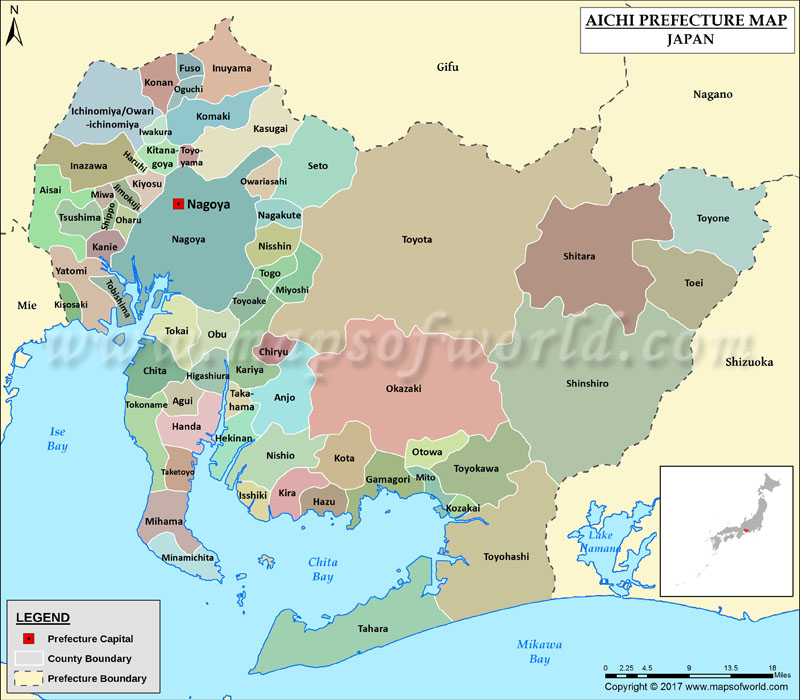 800×700 aichi prefecture map map aichi prefecture japan from www.mapsofworld.com
  1300×777 map aichi prefecture japan location japanese map stock from www.alamy.com
  1000×879 aichi prefecture map flag stock vektorgrafik adobe stock from stock.adobe.com
  474×355 aichi prefecture nagoya meshi washoku lovers from washokulovers.com
  1300×1301 map aichi res stock photography images alamy from www.alamy.com
  450×469 map aichi prefecture municipalities stock illustration from www.pixtastock.com
  1000×960 aichi prefecture nipponcom from www.nippon.com
  1181×901 aichi prefecture from en-academic.com
  728×425 aichi prefecture japan map aichi jp aichi prefecture from www.worldatlas.com
  1500×1593 aichi prefecture map images stock vectors shutterstock from www.shutterstock.com
  354×280 aichi map images stock vectors shutterstock from www.shutterstock.com
  474×474 aichi japan prefecture map britannica from www.britannica.com
  1300×1174 aichi japan map from www.lahistoriaconmapas.com
  310×222 aichi japan from fity.club
  960×540 japan aichi map ofo maps from ofomaps.com
  1200×675 aichi prefecture travel guide lets travel japan from travel-around-japan.com
  583×400 nagoya japan map regions cities aichi prefecture from fity.club
  1300×1390 aichi prefecture highlighted map japan stock vector image from www.alamy.com
  1300×1065 aichi prefecture japan open street map stock photo alamy from www.alamy.com
  1300×1065 aichi prefecture japan colored elevation map lakes rivers from www.alamy.com
  450×418 map aichi prefecture main stock illustration pixta from www.pixtastock.com
  490×496 location aichi prefecture japan scientific diagram from www.researchgate.net
  1068×1068 top aichi prefecture japan from www.thetravelmagazine.net
  1300×1247 shape aichi prefecture japan capital isolated white from www.alamy.com
  392×320 aichi prefecture japan high resolution satellite map locations from www.alamy.com
  1500×1600 high quality map aichi prefecture japan shutterstock from www.shutterstock.com
  260×280 aichi prefecture outline japan map stock vector royalty from www.shutterstock.com
  720×800 map japan provinces aichi highlighted stock photo from www.agefotostock.com