
Alachua County, nestled in North Central Florida, presents a diverse landscape that’s readily apparent on any detailed map. Its prominent feature is the city of Gainesville, the county seat and home to the University of Florida. Gainesville acts as a central hub, radiating roads and communities across the county.
Looking at a map, the presence of numerous lakes and waterways immediately stands out. Prominent among these are Newnans Lake, a large body of water east of Gainesville, and Orange Lake, located to the south. These lakes, connected by waterways, are crucial ecological features, providing habitat for diverse wildlife and contributing to the region’s natural beauty. The Santa Fe River forms the northern border of the county, its winding path marked clearly on the map.
Major roadways crisscross Alachua County, facilitating transportation and connecting its various communities. Interstate 75 (I-75) runs north-south through the western portion of the county, providing access to major cities throughout Florida and beyond. US Highway 441, running parallel to I-75 but closer to Gainesville, connects smaller towns and offers a more scenic route. State Road 24 (Archer Road) is a vital east-west artery within Gainesville, linking the University of Florida to residential and commercial areas. Another key road is State Road 26 (Newberry Road/University Avenue) which traverses Gainesville and connects it to the town of Newberry.
Beyond Gainesville, the map reveals a network of smaller towns and communities, each with its own distinct character. Newberry, located west of Gainesville, is characterized by its historic downtown and equestrian activities. High Springs, northwest of Gainesville, is known for its springs and outdoor recreation opportunities. Alachua, north of Gainesville, offers a mix of residential and commercial development. Hawthorne, situated east of Gainesville, provides a more rural environment.
The topography of Alachua County, while generally flat, reveals subtle variations on the map. Areas around the lakes and rivers tend to be lower-lying, while slightly higher elevations can be found in the more western and northern parts of the county. The presence of conservation lands and state parks, such as Paynes Prairie Preserve State Park south of Gainesville, is also readily identifiable, demonstrating the county’s commitment to preserving its natural environment. These areas are often denoted by green shading on a map, contrasting with the more developed areas surrounding Gainesville and other towns.
In summary, a map of Alachua County offers a glimpse into the county’s diverse geography, its urban center, its numerous lakes and waterways, its connecting roadways, and the surrounding communities that contribute to its unique identity. It’s a valuable tool for understanding the layout and characteristics of this vibrant North Central Florida region.
 800×800 alachua county map florida from www.mapsofworld.com
  810×572 alachua county map florida usa check major cities towns county from www.whereig.com
  1024×682 map alachua county florida stock illustration image from www.istockphoto.com
  1024×656 large detailed map alachua county florida usa stock from www.istockphoto.com
  1000×1080 map alachua county florida usa royalty vector from www.vectorstock.com
  700×1080 alachua florida map map alachua county florida commission district from fity.club
  612×612 large accurate map alachua county florida usa vintage from www.istockphoto.com
  700×452 map alachua county florida from fcit.usf.edu
  749×900 map alachua county florida stock vector illustration florida from www.dreamstime.com
  1024×820 detailed infographic map alachua county florida usa stock from www.istockphoto.com
  800×600 alachua county florida florida smart from www.floridasmart.com
  282×261 alachua county satellite map florida actual satellite from www.city2map.com
  600×436 maps alachua county florida marketmapscom from www.marketmaps.com
  728×425 alachua county florida map oconto county plat map from ocontocountyplatmap.blogspot.com
  600×436 alachua county fl wall map premium style marketmaps mapsales from www.mapsales.com
  1600×1446 map alachua county florida stock vector illustration federal from www.dreamstime.com
  698×698 alachua county florida towns cities from www.florida-backroads-travel.com
  576×576 map alachua county florida state white background single from www.dreamstime.com
  900×605 alachua county from fcit.usf.edu
  1000×1080 map alachua county florida royalty vector image from www.vectorstock.com
 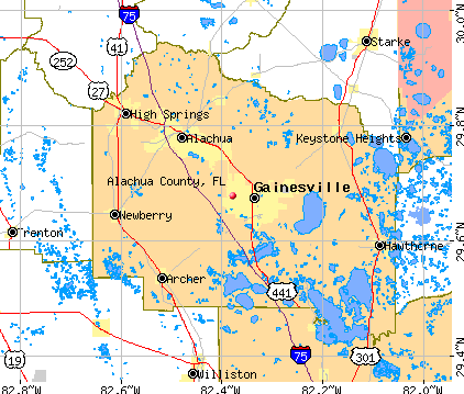 422×359 alachua county florida detailed profile houses real estate cost from www.city-data.com
  600×371 alachua location guide from www.weather-forecast.com
  850×574 physical map alachua county from www.maphill.com
  692×600 image alachua county florida incorporated unincorporated areas from kids.kiddle.co
  1300×1228 map alachua county florida stock photo alamy from www.alamy.com
  600×436 alachua county fl wall map color cast style marketmaps mapsales from www.mapsales.com
  1427×804 cities towns alachua county florida countryaahcom from www.countryaah.com
  800×600 alachua county fl geographic facts maps mapsofnet from www.mapsof.net
  1300×1130 map alachua florida stock photo alamy from www.alamy.com