
A map of Alaska and the Yukon Territory offers a glimpse into a vast and sparsely populated region of North America, dominated by stunning natural landscapes and a rich history. The two territories, while distinct, share geographical features and historical connections, making their combined map particularly informative.
Looking at the map, the sheer size is immediately striking. Alaska, the largest US state, dwarfs many other states in comparison. The Yukon Territory, located to its east, similarly covers a significant land area within Canada. The map highlights a rugged and varied terrain. Coastal areas, especially in southern Alaska, are characterized by intricate networks of fjords, islands, and mountains sculpted by glaciers. The Alexander Archipelago, a group of islands extending along the southeastern coast of Alaska, is a prominent feature.
Moving inland, the towering mountain ranges dominate. The Alaska Range, home to Denali (formerly Mount McKinley), the highest peak in North America, forms a dramatic arc across the state. The Yukon Territory boasts its own impressive mountain ranges, including the Saint Elias Mountains, which straddle the border with Alaska. These mountains are essential for understanding the region’s climate and hydrology, as they collect vast amounts of snow and ice, feeding numerous rivers and glaciers.
Major waterways are crucial elements on the map. The Yukon River, a transboundary river flowing from the Yukon Territory across Alaska and eventually emptying into the Bering Sea, is a defining feature. Its watershed drains a vast area and has historically been a vital transportation route. Other significant rivers include the Kuskokwim, Tanana, and Copper Rivers in Alaska, and the Peel River in the Yukon. These rivers are not only important for transportation and sustenance but also play a vital role in the region’s ecosystem.
The map also reveals the location of communities, which are often clustered along the coast or major rivers due to accessibility and historical patterns of settlement. Anchorage, Alaska’s largest city, and Whitehorse, the capital of the Yukon Territory, stand out as major population centers. Smaller towns and villages, often with a significant Indigenous population, are scattered throughout the region, reflecting the historical dependence on resource extraction and traditional subsistence activities.
Political boundaries are clearly delineated, separating Alaska (USA) from the Yukon Territory (Canada) and other Canadian territories and provinces. However, the map also underscores the shared geographical and ecological characteristics that transcend these political lines. The Bering Strait, separating Alaska from Russia, marks the westernmost point of North America and highlights the region’s strategic location.
In essence, a map of Alaska and the Yukon Territory is a window into a land of extreme beauty and natural resources. It shows a challenging environment that has shaped the lives and cultures of its inhabitants for millennia. From towering mountains and glacial landscapes to vast river systems and isolated communities, the map tells a story of resilience, adaptation, and the enduring power of nature.
 765×546 alaska yukon from www.world-tour-orion7.com
  600×386 tourist map alaska yukon territory from www.cardcow.com
  1300×958 map alaska yukon almire marcelia from drusillaodosi.pages.dev
  1200×1194 map alaska yukon territory explorenorth from explorenorth.com
  615×756 alaska map map pictures from mappictures.blogspot.ca
  474×570 yukon alaska introduction from mopedtrip.com
 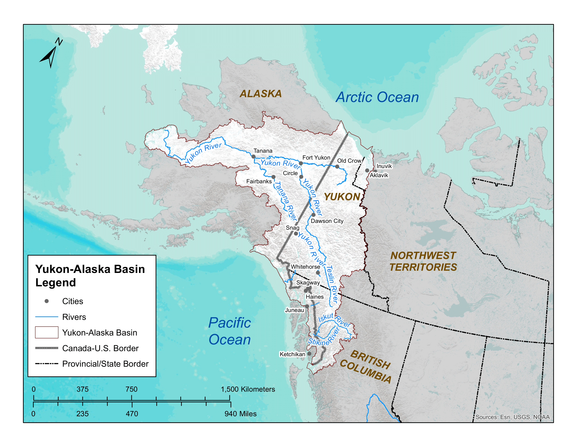 2200×1700 map alaska yukon territory storm bruun from stormmbruun.pages.dev
  500×364 alaska yukon road map georganne flickr from www.flickr.com
  1320×1442 alaska yukon territory map christopher laskey blog from storage.googleapis.com
  818×518 postcardy postcard explorer february from postcardy.blogspot.com
  723×635 map alaska yukon territory showing location fossil sites from www.researchgate.net
  1915×2357 map yukon territory border alaska from pacific-map.com
  1000×1050 list pictures state alaska borders yukon territory from finwise.edu.vn
  606×750 yukon territory map satellite image roads lakes rivers cities from geology.com
  1600×1200 alaska map yukon territory information from yukoninfo.com
  1300×806 map alaska yukon territory british columbia showing connections from www.alamy.com
  630×480 yukon river river north america britannica from www.britannica.com
  909×1110 yukon territory alaska northern british columbia map find overland from www.lastgreatroadtrip.com
  1600×1600 yukon history population facts britannica from www.britannica.com
  736×557 yukon river map alaska alaska map america map from www.pinterest.com
  471×623 yukon territory map from www.pinterest.com
  1119×1600 fort yukon historical settlement north america britannica from www.britannica.com
  1320×1428 alaska maps facts world atlas from www.worldatlas.com
  474×426 map alaska alaska maps cities highways from www.bellsalaska.com
  560×600 road map alaska yukon northwest territories wide world maps from maps4u.com
  474×355 drive yukon alaska explorer alaska alaska yukon american sky from www.americansky.ie
  3840×2336 map alaska ayk nwrs yukon kuskokwim rivers fwsgov from www.fws.gov
  1944×1646 map alaska state usa nations project from www.nationsonline.org
  3008×1697 alaska regions map mapsofnet from mapsof.net
  664×563 simplified map parts eastern alaska yukon northwest from www.researchgate.net