
The Albany area, encompassing the New York state capital and its surrounding towns and villages, boasts a diverse landscape reflected in its maps. Understanding the region’s geography is crucial for navigating its urban centers, exploring its natural beauty, and appreciating its historical significance. Maps of Albany focus on several key features. The Hudson River, a vital waterway throughout the region’s history, is a dominant element. The river flows north-south, bisecting the area and connecting Albany to the Atlantic Ocean. Maps clearly delineate the river’s course, its various inlets and creeks, and the locations of bridges that span its width. The city of Albany itself occupies a strategic location on the river’s west bank. City maps emphasize its street grid, which transitions from an organized downtown core to more residential patterns further out. Major thoroughfares like Central Avenue, Washington Avenue, and New Scotland Avenue are prominently featured, along with important landmarks such as the New York State Capitol building, the Empire State Plaza, and the University at Albany. Beyond Albany, the surrounding counties of Rensselaer, Saratoga, and Schenectady are integral to the regional map. Rensselaer County, lying east of the Hudson, is marked by rolling hills and more rural landscapes. Saratoga County, to the north, offers a mix of suburban development and vast stretches of forests, notably the Saratoga National Historical Park, site of the pivotal Battles of Saratoga during the Revolutionary War. Schenectady County, to the west, is characterized by its industrial history and the presence of the Mohawk River, a tributary of the Hudson. Topographical maps reveal the elevation changes within the Albany area. The Helderberg Escarpment, a dramatic cliff formation west of Albany, is a significant geographical feature, providing panoramic views of the region. The Adirondack Mountains, though located further north, exert a climatic influence on the area. Maps also highlight the presence of numerous lakes and ponds, popular destinations for recreation. Transportation networks are a critical component of any Albany area map. Interstate 90, a major east-west highway, cuts through the region, providing access to Boston and points west. Interstate 87, the Northway, runs north-south, connecting Albany to the Adirondacks and Montreal. The Albany International Airport serves as a regional hub for air travel. Amtrak rail lines also pass through Albany, linking it to major cities along the East Coast. Specialized maps cater to specific interests. Historical maps depict the growth of Albany from a small Dutch trading post to a thriving state capital. Recreational maps highlight hiking trails, bike paths, and parks, such as the Albany Pine Bush Preserve, a unique inland pine barrens ecosystem. Economic development maps showcase industrial parks and areas targeted for future growth. All these map types collectively paint a comprehensive picture of the dynamic Albany area.
 742×634 large detailed map albany ontheworldmapcom from ontheworldmap.com
  1000×506 albany vector map york exact city plan scale full from vectormap.net
  800×705 albany map albany york map capital york albany from www.pinterest.com
  1000×512 albany york map exact city plan full editable vector from vectormap.net
  1910×1955 map albany city york state map roads city albany from pacific-map.com
  2000×2000 albany york printable vector map artofit from www.artofit.org
  1000×506 albany map vector york exact city plan scale full from vectormap.net
  1270×1409 navigating capital region comprehensive guide albany ny from australiarainmap.pages.dev
  600×600 albany york street map from www.landsat.com
  1300×956 albany york usa shown geography map road map stock photo from www.alamy.com
  1600×1156 albany road map area closeup macro view stock photo image from www.dreamstime.com
  612×612 albany york state map united states map from wvcwinterswijk.nl
  474×345 maps albany york marketmapscom from www.marketmaps.com
 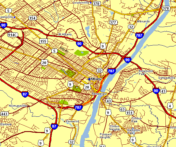 600×500 city map albany from www.new-york-map.info
  900×900 albany york city street map digital art frank ramspott pixels from pixels.com
  800×450 map city albany york geography attractions stats from nchstats.com
  2375×1803 albany york city map albany york mappery from www.mappery.com
  474×345 albany york wall map premium style marketmaps mapsales from www.mapsales.com
  996×725 simple map showing neighborhoods albany ny from www.reddit.com
  800×499 albany york map east map from nickheleira.blogspot.com
  889×757 albany york map vector printable exact city plan full editable from www.reddit.com
  409×390 albany maps york discover albany detailed maps from ontheworldmap.com
  794×699 map albany york etsy from www.etsy.com
 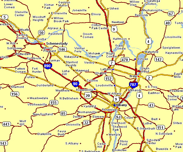 600×500 area map albany from www.new-york-map.info
  642×427 downtown albany map from www.albany.org
  612×594 albany york map premium high res pictures getty images from www.gettyimages.dk
  1300×1154 map albany capital state york stock vector from www.alamy.com
  2000×1641 albany history population map facts britannica from www.britannica.com
  1300×1017 city map albany york stock photo alamy from www.alamy.com
  1500×1320 map albany capital state royalty stock from avopix.com
  728×425 albany ny albany york map worldatlascom from www.worldatlas.com