
Allen Park, Michigan, a suburban city located in Wayne County, boasts a well-defined map reflecting its residential character and community-focused layout. The city’s boundaries are generally accepted as bounded by Dearborn to the north, Melvindale and Lincoln Park to the east, Taylor to the south, and Dearborn Heights and Romulus to the west, providing a convenient location within the Metro Detroit area.
A key geographic feature is its position relative to major transportation routes. Allen Road serves as a major north-south thoroughfare, connecting Allen Park to surrounding communities. Southfield Road, running along the eastern edge, provides another important artery for local traffic. Interstate 94 (I-94) slices through the southern portion of Allen Park, offering direct access to Detroit Metropolitan Airport (DTW) and Downtown Detroit, contributing to the city’s accessibility and desirability for commuters. These highways greatly influence the flow of traffic and shape the commercial zones.
The city’s internal layout largely revolves around residential neighborhoods characterized by single-family homes. The street grid, while not perfectly uniform, is generally well-maintained and facilitates easy navigation. Several parks and recreational areas are strategically positioned throughout the city, contributing to its livability and providing green spaces for residents. One example is Champaign Park, a local favorite.
Commercial activity in Allen Park is concentrated primarily along major roadways, notably Allen Road and Southfield Road. These corridors feature a mix of retail stores, restaurants, and service businesses, catering to the daily needs of the community. Fairlane Green, a large shopping complex located near I-94, draws shoppers from both Allen Park and surrounding areas. Furthermore, the Ford Motor Company’s presence in nearby Dearborn and its influence on the region’s economy contribute to the economic vitality of Allen Park.
The city’s map also reveals the presence of several schools, both public and private, strategically located to serve the needs of the residential areas. These schools are often community hubs, hosting events and activities that bring residents together. The Ecorse Creek runs through the eastern portion of the city, adding a natural element to the urban landscape. While not a major waterway, it contributes to the local ecosystem and provides a scenic backdrop for some residential areas.
Overall, the map of Allen Park illustrates a well-planned and accessible suburban community. Its strategic location near major transportation routes, combined with its focus on residential neighborhoods, parks, and local amenities, makes it an attractive place to live and work within the Detroit metropolitan area. The relatively simple grid layout and concentration of commercial areas along major roads allows for ease of navigation.
 641×641 map allen park michigan from www.w2n.net
  600×600 allen park michigan street map from www.landsat.com
  493×500 amazoncom large street road map allen park michigan mi from www.amazon.com
  300×300 allen park mi from www.bestplaces.net
  1588×1189 allen park map print allen park map poster wall art mi city etsy from www.etsy.com
  400×401 map allen park mi usa from ar.inspiredpencil.com
  988×1258 map allen park mi from ansvers.com
  612×612 aerial photography map allen park mi michigan from www.landsat.com
  300×300 allen park map print allen park map poster wall art mi city map from www.etsy.com
 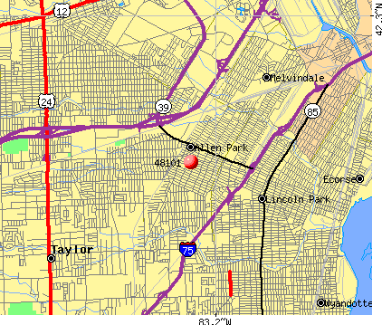 422×359 zip code allen park michigan profile homes apartments from www.city-data.com
  684×521 places compare cost living crime cities schools from www.bestplaces.net
  600×371 guia urbano de allen park from es.weather-forecast.com
 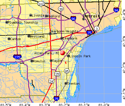 422×359 allen park michigan mi profile population maps real estate from www.city-data.com
  1600×1600 custom allen park united states map poster mapmory from mapmory.com
  1200×1565 allen park crime rates crime statistics neighborhoodscout from www.neighborhoodscout.com
  300×300 places allen park zip michigan from bestplaces.net
  400×298 michigan town decides fire fire department save cash from www.businessinsider.com
  400×400 lawn care allen park mi todays homeowner from todayshomeowner.com
  1001×1300 map allen park city thong thai real from diaocthongthai.com
  769×711 map allen park mi michigan from townmapsusa.com
  800×600 allen park mi geographic facts maps mapsofnet from www.mapsof.net