
The Map of America in 1783 represents a pivotal moment in history: the formal end of the American Revolutionary War and the birth of a new nation, the United States of America. The Treaty of Paris, signed that year, not only acknowledged American independence but also defined the territorial boundaries of this nascent country. Examining this map reveals both the vast potential and the inherent challenges facing the newly formed republic.
The map’s eastern border is relatively straightforward, defined by the Atlantic Ocean. However, moving westward, the picture becomes more complex. The treaty granted the United States all land east of the Mississippi River, extending from the Great Lakes in the north down to approximately the 31st parallel (the northern border of Florida, which remained under Spanish control). This massive expanse of land, often referred to as the “Northwest Territory,” was largely unexplored and sparsely populated by Native American tribes. It represented both immense opportunity for westward expansion and a significant source of future conflict.
The northern border with British Canada was a source of contention. While the Great Lakes were generally recognized as the boundary, the exact line remained vague in certain areas, particularly in the region that would later become Maine. This ambiguity led to disputes over fishing rights and control of valuable fur trading territories.
The southern border was another point of contention. Spain, having assisted the Americans during the revolution, retained control of Florida. The 31st parallel was agreed upon, but Spain disputed the extent of American territory further west, claiming lands that stretched significantly north of that line along the Mississippi River. This disagreement would eventually contribute to future tensions and conflicts between the United States and Spain.
Crucially, the map reveals the presence of Native American nations throughout the newly claimed territory. These nations, who had not been consulted during the treaty negotiations, were viewed by many Americans as obstacles to westward expansion. The map provides a silent commentary on the impending displacement and conflict that would characterize the relationship between the United States and Native Americans in the decades to come.
Furthermore, the map offers a glimpse into the internal divisions within the new nation. The thirteen original states, each fiercely independent, retained considerable power. The central government, operating under the Articles of Confederation, was weak and struggled to effectively govern the vast territory it had acquired. Issues such as land claims, taxation, and interstate commerce threatened to unravel the fragile union.
In conclusion, the Map of America in 1783 is more than just a geographical representation; it is a historical document that encapsulates the hopes, dreams, and challenges of a nation newly born. It highlights the vast potential of the American experiment while also foreshadowing the conflicts and compromises that would shape its future. It is a reminder that the United States, even at its inception, was a complex and evolving entity, constantly grappling with issues of territorial control, national identity, and the rights of its diverse populations.
 618×618 thirteen original states historical maps united states map from mapofusprintable.com
  728×548 map usa from www.edmaps.com
  900×699 united states map painting john russell pixels merch from pixelsmerch.com
  834×834 map emylee philomena from lilianeoglenda.pages.dev
  1300×1215 accurate map united states america part from www.alamy.com
  525×342 map united states ruth cameron from ruthcameron.pages.dev
  1024×768 mapping birth nation america world map flags land from mapfranceswitzerlanditaly.pages.dev
  900×658 territory thirteen original states from etc.usf.edu
  908×800 map united states america settled peace from collections.leventhalmap.org
  722×520 territorial history united states from www.the-map-as-history.com
  1300×1070 original united states map united states map from wvcwinterswijk.nl
  3500×3071 rare early important map united states reflecting from bostonraremaps.com
  1228×877 thirteen original states rmapporn from www.reddit.com
  1024×749 from fity.club
  1300×1223 usa map states names res stock photography images alamy from www.alamy.com
  1024×850 map usa printable map usa from printablemapofusa.com
  3000×2162 rare map united states large yorktown inset rare from bostonraremaps.com
  1140×1279 vintage map united states north america etsy uk from www.etsy.com
  365×473 map united states north america high res stock photo from www.gettyimages.com
  828×1390 map united states close american revolution from www.alamy.com
  373×257 ihb july october from www.in.gov
  1600×1045 history united states britannica from www.britannica.com
  862×1390 map eastern north america eastern states boundaries from www.alamy.com
 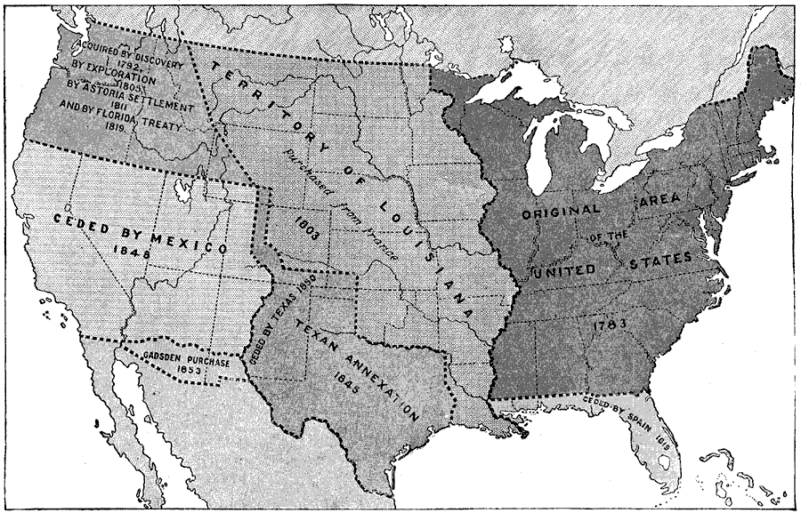 900×577 territorial growth united states from etc.usf.edu
  900×653 map usa showing growth territory state borders from pixels.com
  1300×1012 map territorial growth color lithograph from www.alamy.com
  1024×703 growth united states rmapporn from www.reddit.com
  474×716 original territory united states from etc.usf.edu
  900×640 map united states map from www.deritszalkmaar.nl
  1024×762 united states america territorial expansion vivid maps from vividmaps.com