
Map of American Fork Canyon American Fork Canyon, a jewel of the Wasatch Mountains in Utah, demands exploration aided by a good map. The canyon’s diverse terrain, ranging from paved scenic byways to rugged backcountry trails, makes navigation crucial for a safe and rewarding experience. Different types of maps cater to various needs, from casual sightseeing to serious hiking and rock climbing. For a general overview, commercially available road maps and printed recreational guides are useful. These maps typically highlight the main paved roads, such as the Alpine Loop Scenic Byway, along with prominent landmarks like Timpanogos Cave National Monument, Tibble Fork Reservoir, and Granite Flat Campground. They also often indicate popular picnic areas, viewpoints, and trailheads accessible from the main roads. These maps provide a good starting point for planning a day trip or a leisurely drive. More detailed topographic maps are essential for hiking, backpacking, and other backcountry activities. U.S. Geological Survey (USGS) quadrangle maps, available online or at outdoor retailers, provide accurate elevation contours, stream locations, and trail networks. These maps allow users to assess the steepness of trails, identify water sources, and plan routes based on the terrain. The “Timpanogos Cave” and “Pleasant Grove” quadrangles cover most of American Fork Canyon. Online mapping platforms like Google Maps and Gaia GPS offer digital mapping options. Google Maps provides satellite imagery, street views, and user-generated content, useful for visualizing the canyon’s geography and identifying points of interest. Gaia GPS, on the other hand, is popular among hikers and backpackers for its ability to download offline maps, track routes, and record waypoints. These digital tools are especially helpful for navigating areas with limited cell service, as long as maps are downloaded beforehand. Specific maps are also tailored to particular activities. Rock climbing guidebooks often include detailed topo maps of climbing areas, highlighting routes, ratings, and access trails. Mountain biking maps showcase trail networks, indicating difficulty levels and trail conditions. In winter, avalanche hazard maps are vital for backcountry skiing and snowboarding, delineating areas prone to avalanches based on slope angle, aspect, and snowpack data. When using any map of American Fork Canyon, it’s important to consider its accuracy and scale. Older maps may not reflect recent trail changes or road closures. Map scale determines the level of detail; a larger scale map (e.g., 1:24,000) provides more detail than a smaller scale map (e.g., 1:100,000). Always cross-reference map information with current conditions, weather forecasts, and official park advisories. Combining map skills with sound judgment will ensure a memorable and safe adventure in the beautiful American Fork Canyon.
 1024×925 map american fork canyon printable maps from map.udlvirtual.edu.pe
  850×1423 american fork canyon mountain bike trails trailforks from www.trailforks.com
  474×599 american fork canyon forest service map american fork canyon from www.pinterest.com
  298×386 fillable american fork canyon recreation map fax email print from www.pdffiller.com
  352×515 trail system maps utah hiking beauty from utahhikingbeauty.com
 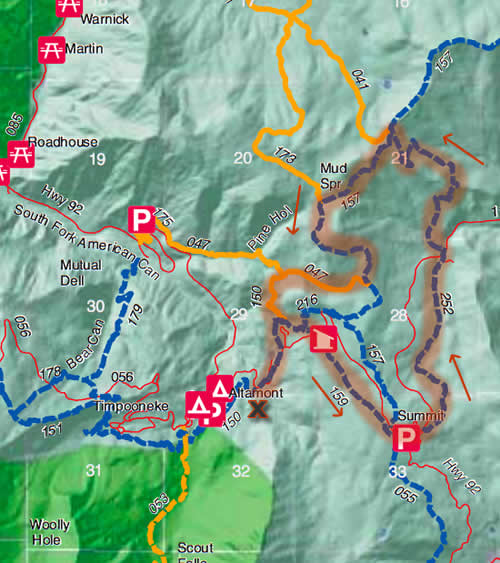 500×563 american fork canyon mountain bike trails open feedthehabitcom from www.feedthehabit.com
  400×505 american fork canyon utahcounty map utah county avenza maps from store.avenza.com
  625×365 american fork canyon hiking list alltrails from www.alltrails.com
  700×508 atsdr pha hc american fork canyonuinta national forest p from www.atsdr.cdc.gov
 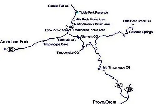 500×335 camping american fork canyon diagrams topos summitpost from www.summitpost.org
 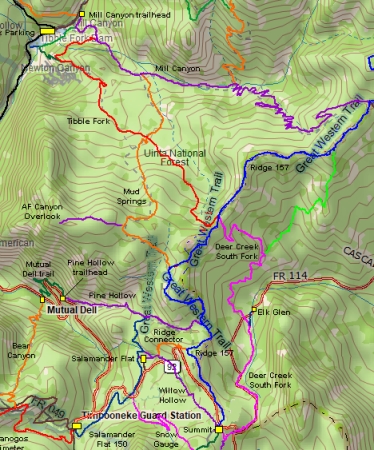 374×450 pine hollow mountain bike trail ultimate guide mountain biking utah from utahmountainbiking.com
  344×236 north fork american fork canyon riding guide from www.utahmountainbiking.com
  1020×1320 american fork canyon alpine loop recreation area interpretive plan from docslib.org
  625×365 running trails american fork utah alltrails from www.alltrails.com
  1200×900 american fork canyon utah hiking beauty from utahhikingbeauty.com
  632×800 american fork single track trail information map plan from www.dirtbikeutah.net
  1355×1341 north fork american fork canyon from utahmountainbiking.com
  625×365 trails american fork utah alltrails from www.alltrails.com
  1650×1275 maps assessment tax confusion american fork canyon alliance from americanforkcanyonalliance.org
  1315×1479 east fork christiana shepherd blog from storage.googleapis.com
  763×240 camping trails american fork alltrails from www.alltrails.com
 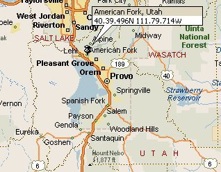 318×248 map american fork utah tourist map english from touristmapofenglish.blogspot.com
  1119×820 af campgrounds american fork canyon alliance from americanforkcanyonalliance.org
  600×371 guia urbano de american fork from es.weather-forecast.com
  1080×810 american fork canyon from www.utahvalley.com
  1280×720 american fork canyon map youtube from www.youtube.com
  544×646 american fork canyon wikipedia from en.wikipedia.org