
Map of Ancient Ephesus: A Journey Through Time
Exploring a map of ancient Ephesus in Turkey is like embarking on a virtual journey through centuries of history. Ephesus, once a thriving Greek city, later Roman capital of Asia Minor, boasts a remarkable wealth of well-preserved ruins that tell the story of a vibrant and complex civilization. A detailed map provides essential context for understanding the city’s layout and significance.
Central to any map of Ephesus is the Harbor Street, also known as the Arcadian Way. This wide, colonnaded avenue was the main thoroughfare leading from the harbor, now silted up, to the heart of the city. Imagine the bustling activity of merchants and citizens as they navigated this grand street.
Rising above the Harbor Street is the magnificent Ephesus Theatre. Capable of seating up to 25,000 spectators, it dominates the landscape. A map highlights its strategic location on the slope of Mount Pion and its function as a center for entertainment and public gatherings. Nearby, you’ll find the Upper Gymnasium, reflecting the importance of physical fitness and training in Ephesian society.
Heading inland, the Marble Road and the Curetes Street are two parallel streets that lead towards the city’s administrative and religious center. Along Curetes Street, you’ll discover the remains of impressive structures such as the Library of Celsus, a stunning example of Roman architecture, and the Gate of Mazaeus and Mithridates, a triumphal arch dedicated to Roman emperors.
The Library of Celsus, with its meticulously reconstructed facade, is a highlight on any Ephesus map. The map shows how it faced east, designed to capture morning light for reading and study. It also reveals the location of a hidden chamber beneath the library, containing the sarcophagus of Celsus Polemaeanus.
Further up Curetes Street, you’ll encounter the Temple of Hadrian, dedicated to the deified Roman emperor Hadrian. The temple’s intricate carvings and well-preserved facade offer a glimpse into the city’s Roman imperial cult. A map also marks the location of the Scholastica Baths, a large public bath complex reflecting the Roman emphasis on hygiene and social interaction.
Away from the central city, maps often indicate the location of the Temple of Artemis, one of the Seven Wonders of the Ancient World. Although little remains of this colossal structure, its historical significance is undeniable. The temple’s placement outside the city walls illustrates its role as a major pilgrimage site.
By consulting a map of Ephesus, visitors can better appreciate the scale and complexity of this ancient city. It allows them to trace the paths of ancient Ephesians, visualize the city’s architectural grandeur, and understand its important role in the history of the Mediterranean world. The map serves as a vital tool for unlocking the secrets of Ephesus and connecting with its rich past.
 1365×1024 ephesus turkey map travel guide from www.adventuretravelcoach.com
  1024×713 visiting ruins ephesus ancient city turkey from www.storiesbysoumya.com
 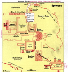 228×240 map ancient ephesos ephesus selcuk turkey mappery from www.mappery.com
  1100×585 ephesus map from www.ephesus.co
  838×591 ephesus plan ephesus turkey from www.ephesusturkey.com
  1200×873 map showing ephesus from ar.inspiredpencil.com
  620×412 map site ancient ephesus efes buy vintage map from www.discusmedia.com
  330×328 ephesus turkey from ermakvagus.com
  1302×1016 ephesus from www.kairos2.com
  478×316 ephesus turkey map burrardlawcom from burrardlaw.com
  735×476 ephesus map bible times google search ephesians bible history from www.pinterest.com
  1000×667 ephesians maps casual english bible from www.casualenglishbible.com
  474×267 ephesus ancient greece map oconto county plat map from ocontocountyplatmap.blogspot.com
  1200×859 ephesus turkey blog interesting places from www.pizzatravel.com.ua
  0 x 0 ephesus map location youtube from www.youtube.com
  1024×1365 visiting ephesus selcuk turkey exploring ancient ruins from haleyblackall.com
  450×263 ephesus nancygo history from nancygo.com
  640×389 selcuk turkey visiting ancient city ephesus from www.ditchthemap.com
  918×1379 ephesus map ephesus map ancient cities from www.pinterest.com
  734×371 ephesus map turkey map sea map usa travel map summer italy kusadasi from www.pinterest.co.uk
  583×290 ephesus turkey map treasures turkiye istanbul ancient ephesus from fity.club
  736×471 ephesus location ephesus turkey ephesus blessed from www.pinterest.co.uk
  1100×701 ancient city ephesus map from www.ephesus.co
  1016×766 ephesus location map from mungfali.com
  919×548 ephesus ancient city ephesus centrum selcuk hotel from www.ephesuscentrum.com
  1200×628 ephesus map ephesus turkey turkiye from www.mappingeurope.com
  750×366 map ephesus visiting ephesus from www.theephesus.com
  200×300 visiting ancient city ephesus turkey travel guide tours from www.araioflight.com
  1600×1178 ephesus ancient city turkey roman ruins britannica from www.britannica.com