
Alabaster, Alabama, located in Shelby County, is a rapidly growing city with a diverse landscape and a well-defined map. Understanding the geography and key locations within Alabaster is essential for residents, visitors, and businesses alike.
The city’s layout largely follows a north-south orientation, bisected primarily by Highway 31 and Interstate 65. These major thoroughfares serve as crucial arteries for transportation, connecting Alabaster to Birmingham to the north and other areas of Alabama to the south.
Key Landmarks and Areas
- Highway 31 Corridor: This stretch is the original commercial center of Alabaster. It’s home to many established businesses, retail stores, restaurants, and local services. Traveling along Highway 31 provides access to older residential neighborhoods and a glimpse into Alabaster’s history.
- Interstate 65 Corridor: Parallel to Highway 31 but further west, the I-65 corridor represents newer commercial development. It boasts shopping centers like the Alabaster Promenade, numerous chain restaurants, hotels, and car dealerships. Its easy access to the interstate makes it a convenient location for travelers.
- Shelby County 11/Kent Dairy Road: This area is seeing significant residential and commercial growth. It connects to major residential areas and provides access to schools and parks. This route is crucial for navigating the city’s expanding suburban landscape.
- Veterans Park: A significant recreational space for the community. It includes sports fields, walking trails, picnic areas, and a large playground. Veterans Park hosts numerous events throughout the year.
- Thompson High School: A major landmark representing the city’s strong emphasis on education. Located near the heart of Alabaster, the school impacts traffic patterns and community events.
- Residential Areas: Alabaster has a mix of established and newly developed neighborhoods. These range from older, more traditional homes along Highway 31 to sprawling subdivisions further west. Developments near Shelby County 11 and Kent Dairy Road feature newer housing options.
- Business and Industrial Parks: Alabaster boasts several business and industrial parks, contributing to the city’s economic development. These areas are strategically located with easy access to major roadways.
Navigating Alabaster
Efficient navigation within Alabaster relies on understanding the grid-like pattern of its main roads, particularly in the newer development zones. While Highway 31 and I-65 are straightforward, side streets can sometimes be less direct. Utilizing GPS navigation systems is highly recommended, especially for newcomers.
The city’s map reflects its transition from a smaller town to a thriving suburban center. The ongoing development projects are continually reshaping its landscape, making it crucial to stay updated with the latest road construction and area changes. As Alabaster continues to grow, its map will undoubtedly evolve to accommodate its expanding population and economy.
 641×641 aerial photography map alabaster al alabama from www.landsat.com
  612×612 alabaster alabama street map from www.landsat.com
  1600×1008 barthet gallery alabaster map from thebarthetgallery.blogspot.com
  480×480 alabaster al wooden street map burnt laser cut wall art from ontahoetime.com
  422×359 alabaster alabama al profile population maps real estate from www.city-data.com
  600×371 alabaster location guide from www.weather-forecast.com
  794×774 alabaster al canvas print al alabama vintage map city town etsy from www.etsy.com
  600×900 retro map alabaster alabama vintage street map stock from www.dreamstime.com
  338×338 alabaster alabama area map from www.thedirectory.org
  1588×1189 alabaster map print alabaster map poster wall art al city etsy from www.etsy.com
  736×736 alabaster alabama street map street map alabaster map from www.pinterest.com
  300×300 alabaster map print alabaster map poster wall art al city map from www.etsy.com
  260×300 alabaster al hotels motels discounts from hotelguides.com
  1300×956 alabaster alabama usa shown road map geography map stock photo from www.alamy.com
  300×300 places alabaster alabama from www.bestplaces.net
 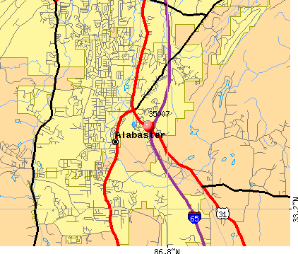 422×359 zip code alabaster alabama profile homes apartments from www.city-data.com
  800×1066 alabaster located alabama usa from www.mapsofworld.com
  420×350 alabaster profile alabaster al population crime map from www.idcide.com
  2000×2000 alabaster alabama street map street map travelers rest nc map from www.pinterest.com
  684×521 places compare cost living crime cities schools from www.bestplaces.net
  200×245 map alabaster al high res pastmaps from pastmaps.com
  1039×1390 alabaster alabama map res stock photography images alamy from www.alamy.com
  1000×1000 fototapeta mapa swiata dla dzieci blueprint city map alabaster from ulala.com.pl
  390×280 alabaster alabama usa map stock photo shutterstock from www.shutterstock.com
  660×1300 map alabaster city thong thai real from diaocthongthai.com
  947×1600 alabaster city location alabama map stock vector royalty from www.shutterstock.com
  1066×1390 alabaster map res stock photography images alamy from www.alamy.com
  800×496 alabaster al usa location map alabaster alabama from www.whereig.com
  640×480 alabaster al geographic facts maps mapsofnet from www.mapsof.net