
The Philippines, an archipelago of over 7,000 islands, relies heavily on air travel to connect its diverse regions and facilitate tourism and commerce. A map showcasing the airports within the country reveals a complex network, reflecting the geographical challenges and the importance of aviation to the nation’s connectivity.
Major international gateways like Ninoy Aquino International Airport (NAIA) in Manila and Mactan-Cebu International Airport (MCIA) in Cebu are easily identifiable on the map. NAIA, the primary international airport, serves the capital region and handles the largest volume of passenger traffic. MCIA, located in the Visayas region, is a crucial hub for the central Philippines, facilitating international and domestic flights. These airports boast modern facilities, multiple terminals, and connections to destinations worldwide.
Beyond the major hubs, the map unveils a tapestry of domestic airports, ranging from medium-sized facilities serving provincial capitals to smaller airstrips catering to island communities. Luzon, the largest island, features a dense concentration of airports including Clark International Airport (CRK), a rapidly growing alternative to NAIA, and several regional airports like Laoag International Airport (LAO) in the north and Legazpi Airport (LGP) in the south, providing access to tourist destinations such as Mount Mayon.
The Visayas region, composed of numerous islands, depends heavily on air transport. Key airports in this region include Iloilo International Airport (ILO) on Panay Island, Bacolod-Silay Airport (BCD) on Negros Island, and Tacloban Airport (TAC) on Leyte Island. These airports connect the islands internally and offer connections to Manila and other major cities. The proliferation of smaller airports and airstrips in the Visayas underscores the necessity of air travel for inter-island connectivity.
Mindanao, the southernmost major island, also features a significant number of airports. Davao International Airport (DVO) serves as the primary gateway to the region, while other airports like General Santos International Airport (GES) and Laguindingan Airport (CGY) facilitate access to different parts of Mindanao. These airports are vital for trade, tourism, and the movement of people and goods across the island’s diverse landscape.
The airport map of the Philippines also highlights the challenges faced by the country’s aviation infrastructure. Many smaller airports have limited facilities and shorter runways, restricting the types of aircraft that can operate there. Furthermore, some airports are susceptible to weather disruptions, particularly during the monsoon season. The ongoing development and modernization of existing airports, as well as the construction of new ones, are crucial for enhancing connectivity and promoting economic growth across the archipelago. Analyzing the airport map provides valuable insights into the distribution of infrastructure, the challenges of geographical fragmentation, and the crucial role of aviation in linking the Philippines’ diverse regions.
 1161×1061 philippines airports map plane flight tracker from www.planeflighttracker.com
  800×1132 airports philippines philippines airports map from www.mapsofworld.com
  1000×1560 map list philippine airports discover philippines from www.discoverthephilippines.com
  800×1127 philippines map from www.worldmap1.com
  531×526 airports philippines design plane from design-plane.blogspot.com
  711×917 international airports philippines virac zambales philippines from www.pinterest.com
  235×407 airport map philippines beautiful phillipines pinterest from www.pinterest.cl
  1006×1002 airports philippines map alysia margeaux from madelineobrigid.pages.dev
  500×615 detailed map philippines tracking philippines from www.top-destination-choice-the-philippines.com
  1100×778 passengers capacity philippines top busiest airports from spatialstories.weebly.com
  1196×869 exciting centennial philippine aviation dotr unveils major from philippineairspace.blogspot.com
  437×669 philippines maps major cities overview from www.pinterest.com
  469×406 airports philippines dotr scientific diagram from www.researchgate.net
  800×979 clark international airport plan international travel info travel from www.pinterest.ph
 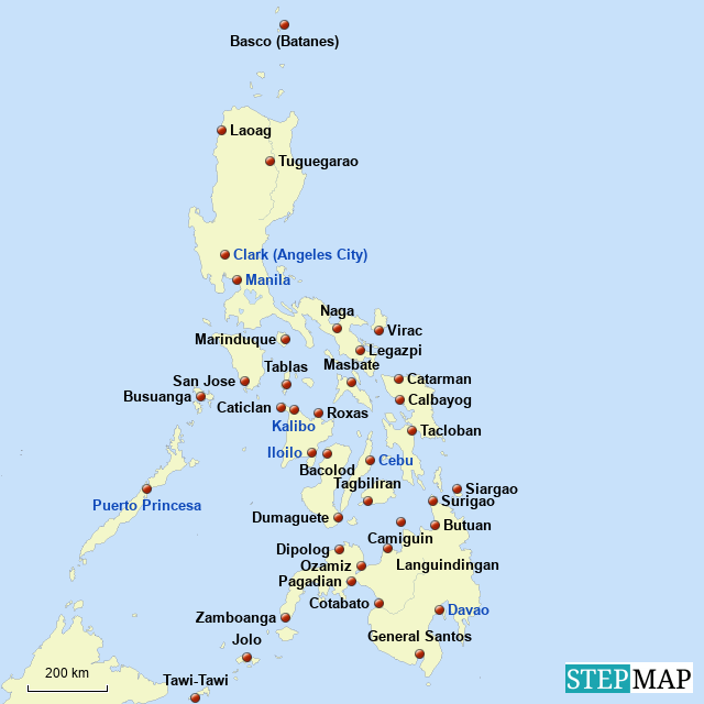 640×640 stepmap philippine airports landkarte fur philippines from www.stepmap.com
  1018×720 airports philippines map svg vector map airports from www.worldmaphd.com
  640×640 airports philippines philippines airports map airport map from www.pinterest.com
  540×540 philippines expand domestic airports smart aviation asia pacific from smartaviation-apac.com
  1412×2086 large physical map philippines roads cities airports from www.mapsland.com
  370×383 philippines domestic airports maps from www.silent-gardens.com
  627×600 map manila ninoy aquino international airport naia from www.manila-airport.net
  930×551 manila philippines airport map from fity.club
  1534×1572 manila airport maps from www.silent-gardens.com
  1024×683 philippines clark international airport grows foreign airlines from centreforaviation.com
  784×1152 maps philippines detailed map philippines english tourist from www.maps-of-the-world.net
  1663×1633 ninoy aquino international airport map from ar.inspiredpencil.com
  1080×880 maps philippines collection maps philippines asia from www.mapsland.com
  992×1319 philippines airports map airports philippines vrogueco from www.vrogue.co
  1800×1080 list airports philippines lumina homes from www.lumina.com.ph
  1024×684 philippines airports iata codes map travel information from getbybus.com