
Washington State boasts a comprehensive network of airports, ranging from large international hubs to smaller, regional and general aviation facilities. Understanding their location and function is crucial for travel planning, freight transport, and emergency response within the state.
Major Commercial Airports
The most prominent airport in Washington is Seattle-Tacoma International Airport (SEA), commonly known as SeaTac. Located just south of Seattle, it’s a major gateway for domestic and international flights, serving as a hub for Alaska Airlines. Its map location is easily identifiable due to its size and the volume of air traffic it handles.
Other significant commercial airports include Spokane International Airport (GEG), serving Eastern Washington and parts of Idaho. It handles a considerable amount of passenger traffic and cargo. Paine Field (PAE) in Everett, north of Seattle, has expanded its commercial operations in recent years, offering an alternative to SeaTac, particularly for destinations on the West Coast.
Smaller commercial airports like Tri-Cities Airport (PSC) in Pasco, Yakima Air Terminal-McAllister Field (YKM), and Pullman-Moscow Regional Airport (PUW) provide regional connectivity, facilitating travel within the state and to nearby areas in Oregon and Idaho.
Regional and General Aviation Airports
Beyond the major players, Washington State features numerous regional and general aviation airports. These smaller airports are essential for connecting rural communities, supporting business aviation, and providing access for emergency services like medevac and firefighting. Examples include Friday Harbor Airport (FRD) on San Juan Island, Walla Walla Regional Airport (ALW), and Bowerman Airport (HQM) in Hoquiam.
These airports are crucial for supporting industries like agriculture, forestry, and tourism, allowing for the rapid movement of goods and personnel. Many also serve as bases for flight training and recreational flying.
Interpreting an Airport Map
A map of Washington State’s airports typically uses symbols to differentiate between commercial, regional, and private facilities. Larger airports are often marked with more prominent symbols and include the IATA and ICAO codes (e.g., SEA, KSEA). Clicking on an airport marker usually provides details such as the airport’s name, location coordinates, runway length, and services offered.
Understanding the geographic distribution of these airports reveals the state’s commitment to air connectivity. Airports along the coast facilitate access to the Olympic Peninsula and island communities. Airports in the Cascade Mountains support recreational activities like skiing and hiking. Eastern Washington airports serve the agricultural heartland.
Importance of Airport Mapping
Accurate and accessible airport maps are vital for pilots, air traffic controllers, emergency responders, and anyone involved in the aviation industry. They contribute to safe and efficient air travel, support economic development, and enhance the state’s overall transportation infrastructure.
Online resources, such as the Washington State Department of Transportation Aviation Division website, provide interactive maps and detailed information about all airports within the state.
 800×625 airports washington state washington airports map from www.mapsofworld.com
  1024×631 map airports washington state from ansvers.com
  730×410 guide airports washington state usa from www.destguides.com
  1000×659 map airports washington state printable maps from map.udlvirtual.edu.pe
  1024×786 airports washington dc map map from deritszalkmaar.nl
  1200×1200 washington state map airports almire marcelia from drusillaodosi.pages.dev
  1024×728 washington state airports map printable map from free-printablemap.com
  253×221 airports map washington state printable vector maps from your-vector-maps.com
  1200×927 washington airports map top airports washington from worldmapwithcountries.net
  474×430 commercial airports washington state from ar.inspiredpencil.com
  450×325 map ronald reagan washington national airport dca orientation from washington-dca.airports-guides.com
  1536×1025 washington airport siting commission shortlists locations from www.theurbanist.org
  2250×1800 ronald reagan washington national airport map ontheworldmapcom from ontheworldmap.com
 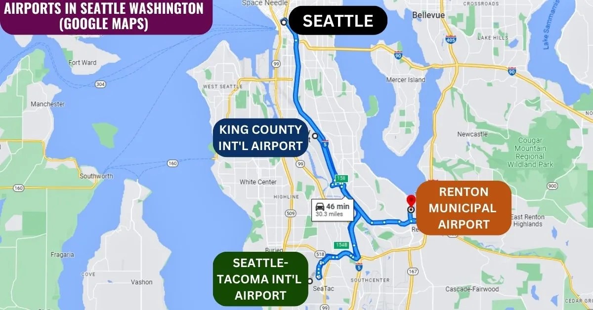 1200×628 explore major airports seattle wa from aviatechchannel.com
  1400×958 seattle tacoma airport seatac washington state full guide from airportix.com
  730×510 king county international airport map washington from www.mapsofworld.com
  230×314 maps washington state big begins from choosewashingtonstate.com
  640×737 airport geography airports metropolitan washington council from www.mwcog.org
  440×310 sky harbor airport washington wikipedia from en.wikipedia.org
  500×202 check historic airline maps washingtons airports from ggwash.org
 /airports-56bdeaff5f9b5829f85ff783.jpg) 1024×652 washington dc airports maps directions from www.tripsavvy.com
1024×652 washington dc airports maps directions from www.tripsavvy.com