
Australia and Antarctica, two continents linked by proximity and significant geological history, present fascinating cartographic features. A map showcasing both reveals stark contrasts in topography, climate, and human impact.
Australia, the smallest continent, is largely defined by its vast interior deserts, such as the Great Victoria Desert and the Simpson Desert. These arid regions dominate the center of the map, characterized by sandy plains, rocky outcrops, and sparse vegetation. Moving outwards, the map shows more fertile lands along the coastlines. The Great Dividing Range, a significant mountain range, runs along the eastern coast, acting as a watershed and influencing rainfall patterns. The iconic Great Barrier Reef, a UNESCO World Heritage Site, stretches along Queensland’s coast, depicted as a complex network of coral reefs and islands. Western Australia boasts dramatic coastlines with the Kimberley region’s rugged gorges and the Nullarbor Plain’s vast, treeless expanse.
Key features on an Australian map include major cities like Sydney, Melbourne, Brisbane, Perth, and Adelaide, all located along the coast due to historical settlement patterns and access to resources. The map also highlights important geographical landmarks such as Uluru (Ayers Rock), a massive sandstone monolith in the heart of the continent, and Kakadu National Park, a rich biodiversity hotspot in the Northern Territory. River systems, like the Murray-Darling Basin, appear as vital lifelines in the arid landscape, often depicted with varying levels of water availability depending on rainfall and usage.
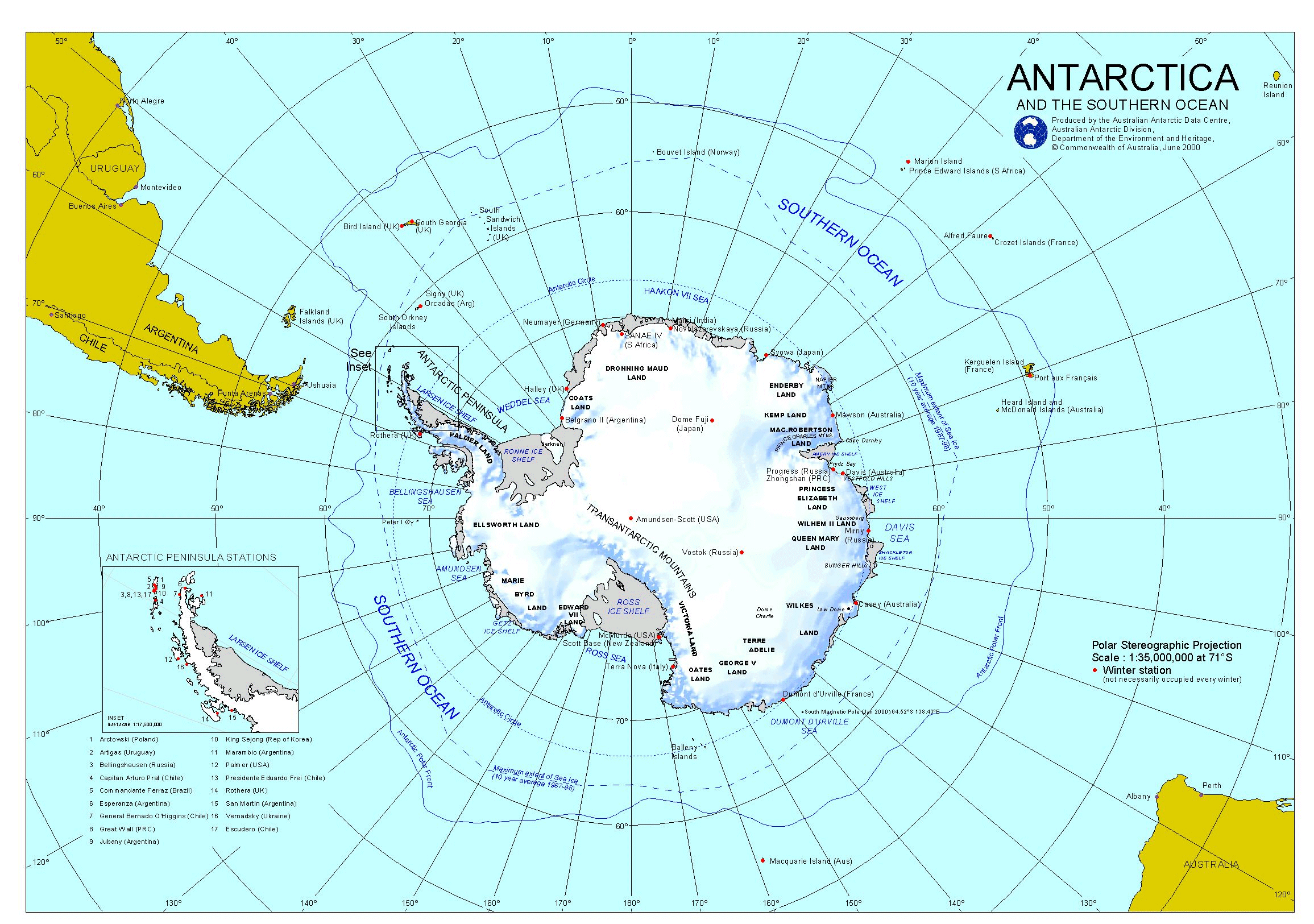
In stark contrast, Antarctica, the ice-covered continent, dominates the bottom of such a map. Its outline is largely defined by ice shelves extending into the surrounding Southern Ocean. The Antarctic landmass is almost entirely covered by a massive ice sheet, the largest single mass of ice on Earth. This feature is typically rendered in white or pale blue, obscuring much of the underlying topography.
The Transantarctic Mountains, one of the world’s longest mountain ranges, bisect the continent, forming a visible barrier across the ice sheet. Coastal regions, where limited ice-free areas exist, reveal rocky landscapes and research stations established by various nations. The Ross Ice Shelf and the Ronne Ice Shelf are prominent features, vast floating platforms of ice that are subject to ongoing research due to their sensitivity to climate change. The South Pole, the southernmost point on Earth, is usually marked on the map, often near research facilities.
Unlike Australia’s relatively detailed network of roads and settlements, the Antarctic map shows primarily research stations and scientific outposts, reflecting the continent’s status as a scientific reserve. Understanding the interaction between these two vastly different continents, especially concerning climate patterns and ocean currents, is crucial. The map serves as a visual representation of their geographical relationship and underscores the importance of studying both regions to better understand global environmental processes.
 2311×1625 antarctica map antarctica mappery from www.mappery.com
  3500×3865 antarctica map detailed maps antarctica from ontheworldmap.com
  350×224 australia antarctica labeling map aj boyle tpt from www.teacherspayteachers.com
 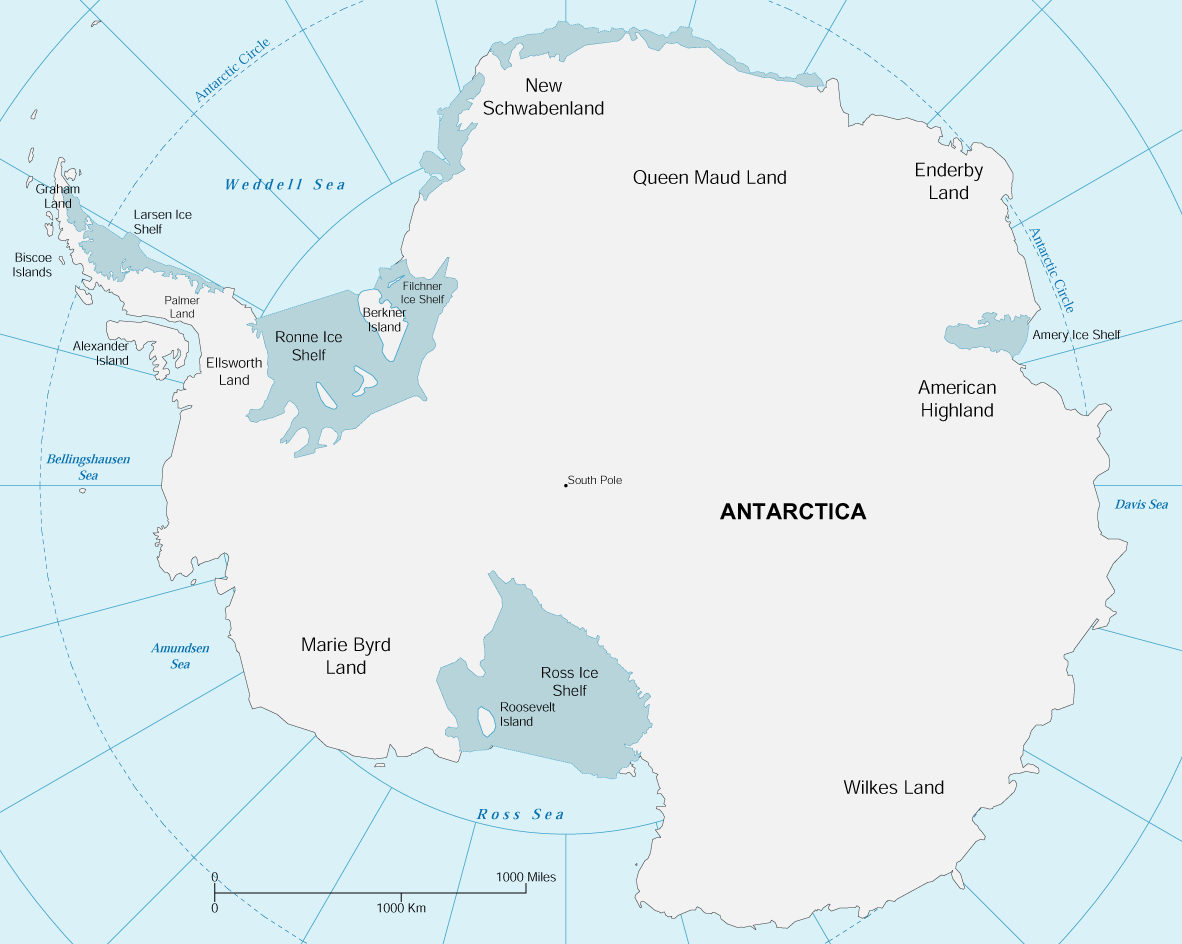 1182×944 map antarctica from www.geographicguide.com
  1164×899 antarctica map from fity.club
  1080×1080 australia antarctica home blizzard from mawsonshuts.antarctica.gov.au
  1000×804 antarctica map continents map archive wall maps from www.natgeomaps.com
  1000×1000 antarctica wall map geographica from geographica.net.au
  615×579 antarctica map travelsfinderscom from travelsfinders.com
  2048×1448 antarctica world maps from worldinmaps.com
  1080×1080 antarctic subantarctic maps australian antarctic program from www.antarctica.gov.au
  350×350 australia antarctica maps worksheets crazyeducation from www.teacherspayteachers.com
  810×801 map antarctica from www.worldmap1.com
  512×505 au antarctican navy from www.alternateuniversewarships.com
  1200×1200 maps antarctica mapswire from mapswire.com
  900×900 australian antarctic jobs from jobs.antarctica.gov.au
  980×1188 map showing australian sector antarctica naagovau from www.naa.gov.au
  990×1220 map antarctica full size from www.zonu.com
  600×559 antarctica maps antarctica maps map pictures from www.wpmap.org
  954×716 map antarctica lessons kids writing planning science lessons from www.pinterest.com.au
  1024×843 map antarctica printable printable word searches from davida.davivienda.com
  1665×1985 large detailed map antarctica antarctic region world mapsland from www.mapsland.com
  598×768 australia antarctica split artofit from www.artofit.org
  1600×881 research stations australian antarctic program from www.antarctica.gov.au
  1432×1250 political map antarctica living room design images from www.tpsearchtool.com
  1600×900 antarctic antarctic maps australian antarctic program from www.antarctica.gov.au
  662×687 printable map antarctica printable world map map maps from in.pinterest.com
  514×600 map meets eye australian antarctic program news from www.antarctica.gov.au